
Geographic Region: USA-NEBRASKA
Feature: PLATTE RIVER
|
Geographic Region: USA-NEBRASKA Feature: PLATTE RIVER |
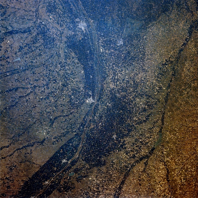 |
| STS028-071-091 Central Nebraska, U.S.A. August 1989 The dark agricultural lands of the Platte River Valley are apparent in this west-looking, low-oblique photograph. The Platte River flood plain in this region is more than 10 miles (16 kilometers) wide. Kearney (near the center) is a commercial, industrial, and transportation center in this agricultural area. Products include farm and irrigation equipment. Near the present city of Kearney, Fort Kearney was established in 1848 to protect settlers moving westward on the Oregon Trail; the fort was abandoned in 1871. East of Kearney on the Wood River near its junction with the Platte River is Grand Island, a major manufacturing and shipping center for this livestock, grain, and dairy region of central Nebraska. South of Grand Island is Hastings (barely discernible). Visible to the south of the Platte are the Republican River, and to the north are portions of the Sand Hills. |
| Images: | All Available Images Low-Resolution 467k |
|
| Mission: | STS028 |
|
| Roll - Frame: | 71 - 91 |
|
| Geographical Name: | USA-NEBRASKA |
|
| Features: | PLATTE RIVER |
|
| Center Lat x Lon: | 40.5N x 99W |
|
| Film Exposure: | N | N=Normal exposure, U=Under exposed, O=Over exposed, F=out of Focus |
| Percentage of Cloud Cover-CLDP: | 0 |
|
| Camera:: | HB |
|
| Camera Tilt: | 19 | LO=Low Oblique, HO=High Oblique, NV=Near Vertical |
| Camera Focal Length: | 100 |
|
| Nadir to Photo Center Direction: | SE | The direction from the nadir to the center point, N=North, S=South, E=East, W=West |
| Stereo?: | Y | Y=Yes there is an adjacent picture of the same area, N=No there isn't |
| Orbit Number: | 7 |
|
| Date: | 19890808 | YYYYMMDD |
| Time: | 220834 | GMT HHMMSS |
| Nadir Lat: | 41.3N |
Latitude of suborbital point of spacecraft |
| Nadir Lon: | 99.5W |
Longitude of suborbital point of spacecraft |
| Sun Azimuth: | 256 | Clockwise angle in degrees from north to the sun measured at the nadir point |
| Space Craft Altitude: | 163 | nautical miles |
| Sun Elevation: | 39 | Angle in degrees between the horizon and the sun, measured at the nadir point |
| Land Views: | PLAIN |
|
| Water Views: | RIVER |
|
| Atmosphere Views: | |
|
| Man Made Views: | AGRICULTURE |
|
| City Views: | |
|
Photo is not associated with any sequences | ||
| NASA Home Page |
JSC Home Page |
JSC Digital Image Collection |
Earth Science & Remote Sensing |
|
This service is provided by the International Space Station program and the JSC Earth Science & Remote Sensing Unit, ARES Division, Exploration Integration Science Directorate.

|