
Geographic Region: USA-NORTH DAKOTA
Feature: L. SAKAKAWEA, MO. R, AGR
|
Geographic Region: USA-NORTH DAKOTA Feature: L. SAKAKAWEA, MO. R, AGR |
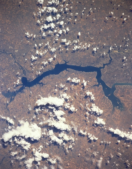 |
| STS028-152-165 Garrison Dam and Lake Sakakawea, North Dakota, U.S.A. August 1989 Lake Sakakawea, with more than 1600 miles (2576 kilometers) of shoreline, is featured in this south-southwest-looking, low-oblique photograph. The lake extends westward almost 200 miles (322 kilometers) to near Williston, North Dakota (not in photograph). A smaller portion of the lake, including the Van Hook Arm, lies within the Fort Berthold Indian Reservation. The part of the Missouri River that forms Lake Sakakawea marks the approximate boundary of glaciers that covered North Dakota--to the east and north glacial deposits blanket the land, and to the west and south lie bedrock and the Bad Lands through which travels the Little Missouri River before entering Lake Sakakawea. Garrison Dam (left center) is one of the largest rolled-earth dams in the world. To its east appear Audubon Lake and the Audubon National Wildlife Refuge. |
| Images: | All Available Images Low-Resolution 315k |
|
| Mission: | STS028 |
|
| Roll - Frame: | 152 - 165 |
|
| Geographical Name: | USA-NORTH DAKOTA |
|
| Features: | L. SAKAKAWEA, MO. R, AGR |
|
| Center Lat x Lon: | 47.5N x 102W |
|
| Film Exposure: | N | N=Normal exposure, U=Under exposed, O=Over exposed, F=out of Focus |
| Percentage of Cloud Cover-CLDP: | 40 |
|
| Camera:: | LH |
|
| Camera Tilt: | 8 | LO=Low Oblique, HO=High Oblique, NV=Near Vertical |
| Camera Focal Length: | 250 |
|
| Nadir to Photo Center Direction: | SE | The direction from the nadir to the center point, N=North, S=South, E=East, W=West |
| Stereo?: | N | Y=Yes there is an adjacent picture of the same area, N=No there isn't |
| Orbit Number: | 38 |
|
| Date: | 19890810 | YYYYMMDD |
| Time: | 205220 | GMT HHMMSS |
| Nadir Lat: | 47.8N |
Latitude of suborbital point of spacecraft |
| Nadir Lon: | 102.2W |
Longitude of suborbital point of spacecraft |
| Sun Azimuth: | 227 | Clockwise angle in degrees from north to the sun measured at the nadir point |
| Space Craft Altitude: | 163 | nautical miles |
| Sun Elevation: | 50 | Angle in degrees between the horizon and the sun, measured at the nadir point |
| Land Views: | PLAIN |
|
| Water Views: | LAKE |
|
| Atmosphere Views: | |
|
| Man Made Views: | DAM |
|
| City Views: | |
|
Photo is not associated with any sequences | ||
| NASA Home Page |
JSC Home Page |
JSC Digital Image Collection |
Earth Science & Remote Sensing |
|
This service is provided by the International Space Station program and the JSC Earth Science & Remote Sensing Unit, ARES Division, Exploration Integration Science Directorate.

|