 Photo #: STS027-39-27 Date: Dec. 1988
Geographic Region: INDIA
Feature: GANGES RIVER

 Photo #: STS027-39-27 Date: Dec. 1988 Photo #: STS027-39-27 Date: Dec. 1988Geographic Region: INDIA Feature: GANGES RIVER |
 |
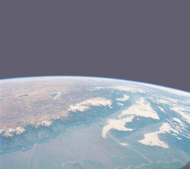
| STS027-039-027 Himalaya Mountains and Northeast India December 1988 This high-oblique, northeast-looking photograph of northeast India and a small part of the Tibetan Plateau of China provides a view of various landforms. Visible is a segment of the east-west trending Himalayas, the world's highest mountain range, with many ridgelines and peaks exceeding 20 000 feet (6095 meters). These mountains were created by the dramatic collision of the Australian-Indian Plate and the Eurasian Plate. The water levels of numerous blue lakes on the high plateau of Tibet are primarily maintained by meltwater from the snow and glaciers of the high Himalayas. Immediately north of these lakes, elevations rise to more than 15 000 feet (4710 meters). In contrast to the arid Tibetan Plateau is the Brahmaputra River valley of northeast India, the world's second wettest spot (the island of Kauai, Hawaii, is the wettest). Most of the rainfall occurs in the Brahmaputra valley during the monsoon season of northeast India. The Brahmaputra River with its braided multichannels bends south around the Kasi Hills of northeast India. A small part of the highly populated Ganges River Plain is visible along the southern edge of the photograph. |
| Images: | All Available Images Low-Resolution 164k |
|
| Mission: | STS027 |
|
| Roll - Frame: | 39 - 27 |
|
| Geographical Name: | INDIA |
|
| Features: | GANGES RIVER |
|
| Center Lat x Lon: | N x E |
|
| Film Exposure: | N | N=Normal exposure, U=Under exposed, O=Over exposed, F=out of Focus |
| Percentage of Cloud Cover-CLDP: | 30 |
|
| Camera:: | HB |
|
| Camera Tilt: | HO | LO=Low Oblique, HO=High Oblique, NV=Near Vertical |
| Camera Focal Length: | 250 |
|
| Nadir to Photo Center Direction: | The direction from the nadir to the center point, N=North, S=South, E=East, W=West |
|
| Stereo?: | N | Y=Yes there is an adjacent picture of the same area, N=No there isn't |
| Orbit Number: | 9 |
|
| Date: | 19881203 | YYYYMMDD |
| Time: | 030054 | GMT HHMMSS |
| Nadir Lat: | 22.2N |
Latitude of suborbital point of spacecraft |
| Nadir Lon: | 85.1E |
Longitude of suborbital point of spacecraft |
| Sun Azimuth: | 131 | Clockwise angle in degrees from north to the sun measured at the nadir point |
| Space Craft Altitude: | 241 | nautical miles |
| Sun Elevation: | 26 | Angle in degrees between the horizon and the sun, measured at the nadir point |
| Land Views: | MOUNTAIN, PLAIN, VALLEY, PLATEAU, HILL |
|
| Water Views: | RIVER, LAKE |
|
| Atmosphere Views: | |
|
| Man Made Views: | |
|
| City Views: | |
|
Photo is not associated with any sequences | ||
| NASA Home Page |
JSC Home Page |
JSC Digital Image Collection |
Earth Science & Remote Sensing |
|
|