Geographic Region: USA-HAWAII
Feature: KURE ISLAND
|
Geographic Region: USA-HAWAII Feature: KURE ISLAND |
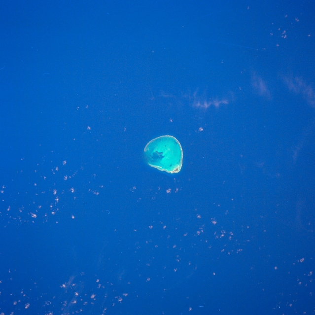 |
| STS026-043-055 Kure Atoll, Hawaii, U.S.A. October 1988 Kure Island, an atoll at the extreme western end of the Hawaiian Islands, lies approximately 60 miles (97 kilometers) west of the Midway Islands in the north-central Pacific Ocean. The atoll, with a diameter of approximately 7 miles (10 kilometers), is a ring of coral reefs encircling a shallow lagoon. Uninhabited by humans, the atoll serves as a bird sanctuary. Green Island is the larger island toward the southeast. |
| Images: | All Available Images Low-Resolution 257k |
|
| Mission: | STS026 |
|
| Roll - Frame: | 43 - 55 |
|
| Geographical Name: | USA-HAWAII |
|
| Features: | KURE ISLAND |
|
| Center Lat x Lon: | 28.5N x 178.5W |
|
| Film Exposure: | N | N=Normal exposure, U=Under exposed, O=Over exposed, F=out of Focus |
| Percentage of Cloud Cover-CLDP: | 5 |
|
| Camera:: | HB |
|
| Camera Tilt: | 15 | LO=Low Oblique, HO=High Oblique, NV=Near Vertical |
| Camera Focal Length: | 250 |
|
| Nadir to Photo Center Direction: | W | The direction from the nadir to the center point, N=North, S=South, E=East, W=West |
| Stereo?: | Y | Y=Yes there is an adjacent picture of the same area, N=No there isn't |
| Orbit Number: | 36 |
|
| Date: | 19881001 | YYYYMMDD |
| Time: | 203245 | GMT HHMMSS |
| Nadir Lat: | 28.4N |
Latitude of suborbital point of spacecraft |
| Nadir Lon: | 177.7W |
Longitude of suborbital point of spacecraft |
| Sun Azimuth: | 117 | Clockwise angle in degrees from north to the sun measured at the nadir point |
| Space Craft Altitude: | 175 | nautical miles |
| Sun Elevation: | 34 | Angle in degrees between the horizon and the sun, measured at the nadir point |
| Land Views: | ATOLL |
|
| Water Views: | LAGOON, REEF |
|
| Atmosphere Views: | |
|
| Man Made Views: | |
|
| City Views: | |
|
Photo is not associated with any sequences | ||
| NASA Home Page |
JSC Home Page |
JSC Digital Image Collection |
Earth Science & Remote Sensing |
|
This service is provided by the International Space Station program and the JSC Earth Science & Remote Sensing Unit, ARES Division, Exploration Integration Science Directorate.

|