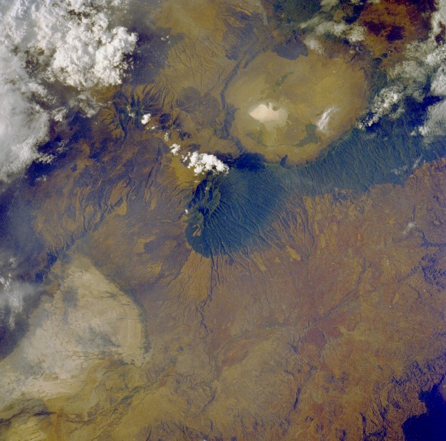
 Photo #: STS026-42-81 Date: Oct. 1988
Geographic Region: TANZANIA
Feature: NGORONGORO CRATER

 Photo #: STS026-42-81 Date: Oct. 1988 Photo #: STS026-42-81 Date: Oct. 1988Geographic Region: TANZANIA Feature: NGORONGORO CRATER |
 |
| STS026-042-081 Ngorongoro Crater, Tanzania September 1988 Ngorongoro Crater, the world's largest caldera that does not contain a lake, is northeast of the forest-covered slopes of Oldeani Volcano (center of the photograph) in this near-vertical photograph. Ngorongoro, which means "huge hole," covers 125 square miles (325 square kilometers) and is 12 miles (20 kilometers) in diameter. Although now dormant, Oldeani Volcano, 10 457 feet (3188 meters) above sea level, was a huge volcanic mountain estimated to be 14 760 feet (4500 meters) above sea level that erupted approximately 3 million years ago and collapsed into the empty magma chamber beneath the crust, leaving a gigantic caldera. The rim of the caldera is nearly 2000 feet (600 meters) above the crater floor, which is a vast grassland with scattered trees and some small freshwater lakes and ponds. A large salt lake (whitish area) has water levels that fluctuate from season to season and year to year. The crater floor is a mecca for abundant wildlife, including wildebeests, gazelles, zebras, lions, hyenas, and cheetahs. Visible southwest of Oldeani Volcano is the northern portion of Lake Eyasi, a large soda lake, the water levels of which also fluctuate from season to season and year to year. All the features in this photograph are part of the Great Rift Valley of eastern Africa. |
| Images: | All Available Images Low-Resolution 138k |
|
| Mission: | STS026 |
|
| Roll - Frame: | 42 - 81 |
|
| Geographical Name: | TANZANIA |
|
| Features: | NGORONGORO CRATER |
|
| Center Lat x Lon: | 3.5S x 35.5E |
|
| Film Exposure: | N | N=Normal exposure, U=Under exposed, O=Over exposed, F=out of Focus |
| Percentage of Cloud Cover-CLDP: | 20 |
|
| Camera:: | HB |
|
| Camera Tilt: | 8 | LO=Low Oblique, HO=High Oblique, NV=Near Vertical |
| Camera Focal Length: | 250 |
|
| Nadir to Photo Center Direction: | NW | The direction from the nadir to the center point, N=North, S=South, E=East, W=West |
| Stereo?: | Y | Y=Yes there is an adjacent picture of the same area, N=No there isn't |
| Orbit Number: | 31 |
|
| Date: | 19881001 | YYYYMMDD |
| Time: | 132543 | GMT HHMMSS |
| Nadir Lat: | 3.8S |
Latitude of suborbital point of spacecraft |
| Nadir Lon: | 35.7E |
Longitude of suborbital point of spacecraft |
| Sun Azimuth: | 268 | Clockwise angle in degrees from north to the sun measured at the nadir point |
| Space Craft Altitude: | 162 | nautical miles |
| Sun Elevation: | 30 | Angle in degrees between the horizon and the sun, measured at the nadir point |
| Land Views: | VOLCANO, CRATER, FOREST, RIFT, VALLEY |
|
| Water Views: | |
|
| Atmosphere Views: | |
|
| Man Made Views: | |
|
| City Views: | |
|
Photo is not associated with any sequences | ||
| NASA Home Page |
JSC Home Page |
JSC Digital Image Collection |
Earth Science & Remote Sensing |
|
|