Geographic Region: USA-HAWAII
Feature: OAHU
|
Geographic Region: USA-HAWAII Feature: OAHU |
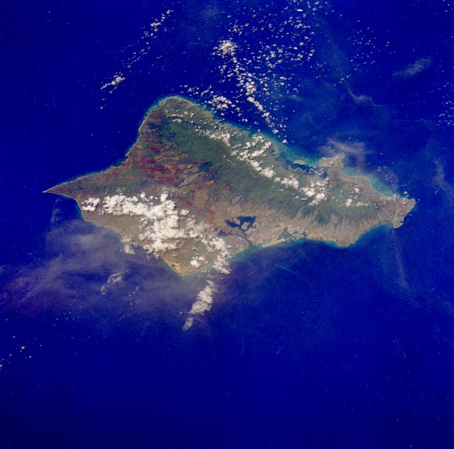 |
| STS026-041-007 Oahu, Hawaii, U.S.A. September 1988 Oahu, third largest and most important of the Hawaiian Islands, can be seen in this low-oblique, north-northeast-looking photograph (the line to true north runs from Pearl Harbor to Kahuka Point). The island covers 598 square miles (1536 square kilometers). Pearl Harbor, the city of Honolulu, and the International Airport's large runway built on a coral reef can be seen near the center of the photograph. Geologically, two great volcanoes once made up the island of Oahu; but, over time, erosion has left the volcanoes as two parallel mountain ranges--Koolau northeast of Honolulu and Waianae northwest of Honolulu (under clouds). The mountain ranges are separated by a rolling plateau dissected by deep gorges, visible north of Honolulu. Oahu has no active volcanoes, but there are many extinct craters, such as Diamond Head, which is visible southeast of Honolulu. Large pineapple plantations cover the central plateau, and sugarcane plantations cover the coastal plains to the north. Population growth and urban development since the late 1960s have depleted a portion of the rural land available for agriculture. Oahu remains an important site for the U.S. Department of Defense, as it includes the headquarters of the United States Pacific Command and the Pearl Harbor Naval Complex. |
| Images: | All Available Images Low-Resolution 117k |
|
| Mission: | STS026 |
|
| Roll - Frame: | 41 - 7 |
|
| Geographical Name: | USA-HAWAII |
|
| Features: | OAHU |
|
| Center Lat x Lon: | 21.5N x 158W |
|
| Film Exposure: | N | N=Normal exposure, U=Under exposed, O=Over exposed, F=out of Focus |
| Percentage of Cloud Cover-CLDP: | 20 |
|
| Camera:: | HB |
|
| Camera Tilt: | 42 | LO=Low Oblique, HO=High Oblique, NV=Near Vertical |
| Camera Focal Length: | 250 |
|
| Nadir to Photo Center Direction: | N | The direction from the nadir to the center point, N=North, S=South, E=East, W=West |
| Stereo?: | N | Y=Yes there is an adjacent picture of the same area, N=No there isn't |
| Orbit Number: | 22 |
|
| Date: | 19880930 | YYYYMMDD |
| Time: | 233643 | GMT HHMMSS |
| Nadir Lat: | 19.1N |
Latitude of suborbital point of spacecraft |
| Nadir Lon: | 158.7W |
Longitude of suborbital point of spacecraft |
| Sun Azimuth: | 220 | Clockwise angle in degrees from north to the sun measured at the nadir point |
| Space Craft Altitude: | 166 | nautical miles |
| Sun Elevation: | 61 | Angle in degrees between the horizon and the sun, measured at the nadir point |
| Land Views: | VOLCANO, MOUNTAIN, VALLEY, COAST, PLAIN, ISLAND |
|
| Water Views: | BAY, INLET, OCEAN |
|
| Atmosphere Views: | |
|
| Man Made Views: | AGRICULTURE, URBAN AREA, AIRPORT |
|
| City Views: | |
|
Photo is not associated with any sequences | ||
| NASA Home Page |
JSC Home Page |
JSC Digital Image Collection |
Earth Science & Remote Sensing |
|
This service is provided by the International Space Station program and the JSC Earth Science & Remote Sensing Unit, ARES Division, Exploration Integration Science Directorate.

|