
Geographic Region: PERU
Feature: NEV. CHACHANI, VOLCANOES
|
Geographic Region: PERU Feature: NEV. CHACHANI, VOLCANOES |
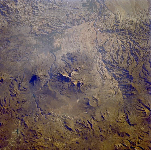 |
| STS026-040-056 El Misti Volcano, Arequipa Area, Peru October 1988 Volcanoes, mountains, and deeply entrenched river valleys appear in this near-vertical photograph of the Arequipa region of southern Peru. The large, multipeaked, snow-capped volcanic structure ascending more than 19 870 feet (6055 meters) above sea level (center of the photograph) is Nevada de Chachani, directly north of which is the large caldera of an unidentified volcano. Southeast of Nevada de Chachani and across the Chili River valley stands El Misti Volcano, a dormant volcano that last erupted in 1870. El Misti (usually snow-capped, but not in this photograph), a cone volcano widely recognized in the Inca religion, has provided inspiration for Peruvian legends and poetry. El Misti rises 19 098 feet (5825 meters) above sea level. Arequipa, one of Peru's larger cities with a population of more than 100 000, sits along the western flank at the foot of El Misti. The city is located on a narrow plain and provides goods and services to southern Peru and northern Chile. Chief exports of this region are leather goods, textiles, foodstuffs, and wool. |
| Images: | All Available Images Low-Resolution 171k |
|
| Mission: | STS026 |
|
| Roll - Frame: | 40 - 56 |
|
| Geographical Name: | PERU |
|
| Features: | NEV. CHACHANI, VOLCANOES |
|
| Center Lat x Lon: | 16S x 71.5W |
|
| Film Exposure: | N | N=Normal exposure, U=Under exposed, O=Over exposed, F=out of Focus |
| Percentage of Cloud Cover-CLDP: | 0 |
|
| Camera:: | HB |
|
| Camera Tilt: | 28 | LO=Low Oblique, HO=High Oblique, NV=Near Vertical |
| Camera Focal Length: | 250 |
|
| Nadir to Photo Center Direction: | S | The direction from the nadir to the center point, N=North, S=South, E=East, W=West |
| Stereo?: | N | Y=Yes there is an adjacent picture of the same area, N=No there isn't |
| Orbit Number: | 52 |
|
| Date: | 19881002 | YYYYMMDD |
| Time: | 211545 | GMT HHMMSS |
| Nadir Lat: | 14.7S |
Latitude of suborbital point of spacecraft |
| Nadir Lon: | 70.9W |
Longitude of suborbital point of spacecraft |
| Sun Azimuth: | 271 | Clockwise angle in degrees from north to the sun measured at the nadir point |
| Space Craft Altitude: | 163 | nautical miles |
| Sun Elevation: | 19 | Angle in degrees between the horizon and the sun, measured at the nadir point |
| Land Views: | MOUNTAIN, VOLCANO, VALLEY, PLATEAU |
|
| Water Views: | RIVER |
|
| Atmosphere Views: | |
|
| Man Made Views: | URBAN AREA |
|
| City Views: | |
|
Photo is not associated with any sequences | ||
| NASA Home Page |
JSC Home Page |
JSC Digital Image Collection |
Earth Science & Remote Sensing |
|
This service is provided by the International Space Station program and the JSC Earth Science & Remote Sensing Unit, ARES Division, Exploration Integration Science Directorate.

|