
Geographic Region: ETHIOPIA
Feature: ERTA ALE
|
Geographic Region: ETHIOPIA Feature: ERTA ALE |
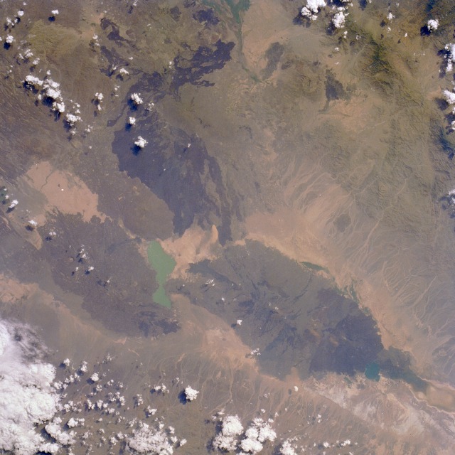 |
| STS026-033-080 Erta Alle Volcano, Ethiopia September 1988 Erta Alle, a shield volcano located within the Rift Valley of northern Ethiopia, is visible in this near-vertical photograph taken north of turquoise Afrera Ye Ch'ew Lake. The volcano, called "the smoking mountain" by the local tribesmen, has an active lava lake (barely discernible in the photograph) approximately 150 feet (46 meters) wide, which has been in a constant state of eruption since the late 1960s. Erta Alle is one of the world's few volcanoes in which permanent lava lakes reside; Kilauea Volcano on the big island of Hawaii is another. Erta Alle is located in the Afar Depression, where the Eastern Rift lies between the Red Sea to the north and east (not included in the photograph) and the Ethiopian Highlands to the west (not included in the photograph). The volcano is in a forbidding region of the Earth--hot, dry, below sea level, and mostly uninhabited. Other dark lava flows are visible from a number of smaller volcanoes south and southwest of the lake. |
| Images: | All Available Images Low-Resolution 118k |
|
| Mission: | STS026 |
|
| Roll - Frame: | 33 - 80 |
|
| Geographical Name: | ETHIOPIA |
|
| Features: | ERTA ALE |
|
| Center Lat x Lon: | 13.5N x 40.5E |
|
| Film Exposure: | N | N=Normal exposure, U=Under exposed, O=Over exposed, F=out of Focus |
| Percentage of Cloud Cover-CLDP: | 20 |
|
| Camera:: | HB |
|
| Camera Tilt: | 14 | LO=Low Oblique, HO=High Oblique, NV=Near Vertical |
| Camera Focal Length: | 100 |
|
| Nadir to Photo Center Direction: | N | The direction from the nadir to the center point, N=North, S=South, E=East, W=West |
| Stereo?: | Y | Y=Yes there is an adjacent picture of the same area, N=No there isn't |
| Orbit Number: | 14 |
|
| Date: | 19880930 | YYYYMMDD |
| Time: | 113514 | GMT HHMMSS |
| Nadir Lat: | 12.8N |
Latitude of suborbital point of spacecraft |
| Nadir Lon: | 40.6E |
Longitude of suborbital point of spacecraft |
| Sun Azimuth: | 249 | Clockwise angle in degrees from north to the sun measured at the nadir point |
| Space Craft Altitude: | 164 | nautical miles |
| Sun Elevation: | 50 | Angle in degrees between the horizon and the sun, measured at the nadir point |
| Land Views: | VOLCANO, CRATER, MOUNTAIN, RIFT |
|
| Water Views: | |
|
| Atmosphere Views: | |
|
| Man Made Views: | |
|
| City Views: | |
|
Photo is not associated with any sequences | ||
| NASA Home Page |
JSC Home Page |
JSC Digital Image Collection |
Earth Science & Remote Sensing |
|
This service is provided by the International Space Station program and the JSC Earth Science & Remote Sensing Unit, ARES Division, Exploration Integration Science Directorate.

|