Geographic Region: CANADA-Q
Feature: MANICOUAGAN RESERVOIR
|
Geographic Region: CANADA-Q Feature: MANICOUAGAN RESERVOIR |
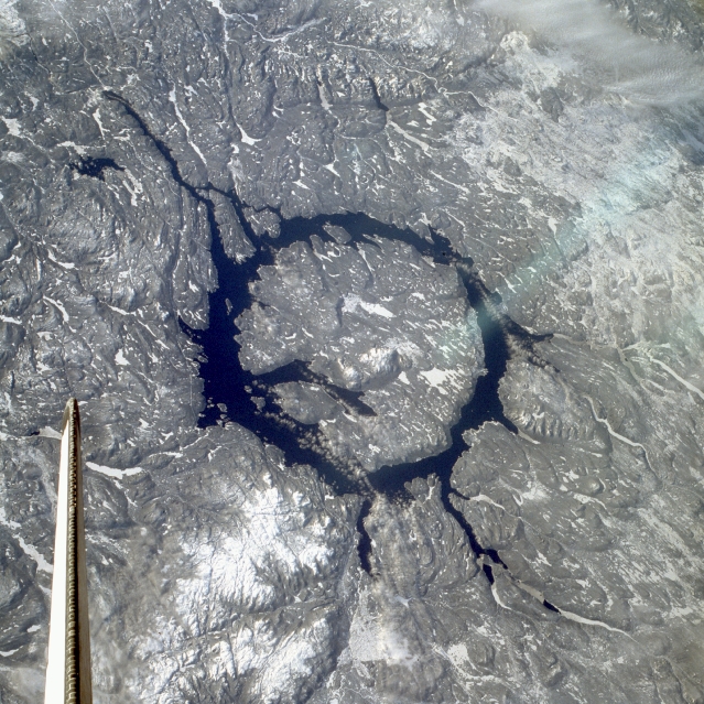 |
| STS009-048-3139 Manicouagan Reservoir, Canada December 1983 Located in a rugged, heavily timbered area of the Canadian Shield in Quebec Province, Manicouagan Reservoir is impressive in this low-oblique, west-looking photograph. The reservoir, a large annular lake, marks the site of an impact crater 60 miles (100 kilometers) wide. Formed almost 212 million years ago when a large meteorite hit Earth, the crater has been worn down by many advances and retreats of glaciers and other processes of erosion. The reservoir is drained at its south end by the Manicouagan River, which flows from the reservoir and empties into the Saint Lawrence River nearly 300 miles (483 kilometers) south. |
| Images: | All Available Images Low-Resolution 389k |
|
| Mission: | STS009 |
|
| Roll - Frame: | 48 - 3139 |
|
| Geographical Name: | CANADA-Q |
|
| Features: | MANICOUAGAN RESERVOIR |
|
| Center Lat x Lon: | 51.5N x 68.5W |
|
| Film Exposure: | N | N=Normal exposure, U=Under exposed, O=Over exposed, F=out of Focus |
| Percentage of Cloud Cover-CLDP: | 5 |
|
| Camera:: | HB |
|
| Camera Tilt: | NV | LO=Low Oblique, HO=High Oblique, NV=Near Vertical |
| Camera Focal Length: | 100 |
|
| Nadir to Photo Center Direction: | The direction from the nadir to the center point, N=North, S=South, E=East, W=West |
|
| Stereo?: | N | Y=Yes there is an adjacent picture of the same area, N=No there isn't |
| Orbit Number: | 97 |
|
| Date: | 1983____ | YYYYMMDD |
| Time: | GMT HHMMSS |
|
| Nadir Lat: | N |
Latitude of suborbital point of spacecraft |
| Nadir Lon: | E |
Longitude of suborbital point of spacecraft |
| Sun Azimuth: | Clockwise angle in degrees from north to the sun measured at the nadir point |
|
| Space Craft Altitude: | nautical miles |
|
| Sun Elevation: | Angle in degrees between the horizon and the sun, measured at the nadir point |
|
| Land Views: | HILL, CRATER, UPLAND |
|
| Water Views: | RESERVOIR, RIVER |
|
| Atmosphere Views: | |
|
| Man Made Views: | |
|
| City Views: | |
|
Photo is not associated with any sequences | ||
| NASA Home Page |
JSC Home Page |
JSC Digital Image Collection |
Earth Science & Remote Sensing |
|
This service is provided by the International Space Station program and the JSC Earth Science & Remote Sensing Unit, ARES Division, Exploration Integration Science Directorate.

|