Geographic Region: CHINA
Feature: HONG KONG
|
Geographic Region: CHINA Feature: HONG KONG |
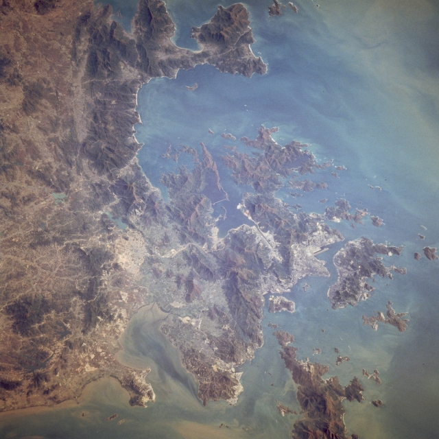 |
| STS009-033-1276 Hong Kong, China December 1983 Hong Kong, an important center of world commerce in the Far East that covers 399 square miles (1033 square kilometers), is discernible in this east-looking, low-oblique photograph. The tan circular area is the Chinese city of Shenzhen. Hong Kong lies adjacent to Guangdong (Kwangtung) Province in southeastern China on the estuary of the Canton River, east of Macao (not visible), and 90 miles (145 kilometers) southeast of the Chinese city of Guangzhou (Canton; not visible). Hong Kong is a free port, a bustling trade center, and a shipping and banking emporium. Major industries include textiles, garment mills, shipbuilding, food processing, plastics, electrical and electronic equipment, rubber products, machinery, chemicals, ceramics, furniture, jewelry, toys, motion picture production, insurance, printing and publishing, and tourism. Because of the mountainous and rocky terrain, approximately only one-seventh of the land is arable. Rice and vegetables are major crops. Ceded by China to Great Britain in 1841 the island of Hong Kong, together with the adjacent regions of Kowloon and the New Territories, was returned to China in 1997. |
| Images: | All Available Images Low-Resolution 326k |
|
| Mission: | STS009 |
|
| Roll - Frame: | 33 - 1276 |
|
| Geographical Name: | CHINA |
|
| Features: | HONG KONG |
|
| Center Lat x Lon: | 22.5N x 114.5E |
|
| Film Exposure: | N | N=Normal exposure, U=Under exposed, O=Over exposed, F=out of Focus |
| Percentage of Cloud Cover-CLDP: | 0 |
|
| Camera:: | HB |
|
| Camera Tilt: | LO | LO=Low Oblique, HO=High Oblique, NV=Near Vertical |
| Camera Focal Length: | 250 |
|
| Nadir to Photo Center Direction: | The direction from the nadir to the center point, N=North, S=South, E=East, W=West |
|
| Stereo?: | Y | Y=Yes there is an adjacent picture of the same area, N=No there isn't |
| Orbit Number: | 24 |
|
| Date: | 1983____ | YYYYMMDD |
| Time: | GMT HHMMSS |
|
| Nadir Lat: | N |
Latitude of suborbital point of spacecraft |
| Nadir Lon: | E |
Longitude of suborbital point of spacecraft |
| Sun Azimuth: | Clockwise angle in degrees from north to the sun measured at the nadir point |
|
| Space Craft Altitude: | nautical miles |
|
| Sun Elevation: | Angle in degrees between the horizon and the sun, measured at the nadir point |
|
| Land Views: | COAST, HILL |
|
| Water Views: | SEDIMENT |
|
| Atmosphere Views: | |
|
| Man Made Views: | URBAN AREA, AIRPORT |
|
| City Views: | HONG KONG, SHENZHEN |
|
Photo is not associated with any sequences | ||
| NASA Home Page |
JSC Home Page |
JSC Digital Image Collection |
Earth Science & Remote Sensing |
|
This service is provided by the International Space Station program and the JSC Earth Science & Remote Sensing Unit, ARES Division, Exploration Integration Science Directorate.

|