
Geographic Region: AUSTRALIA-WA
Feature: LAKE DISAPPOINTMENT
|
Geographic Region: AUSTRALIA-WA Feature: LAKE DISAPPOINTMENT |
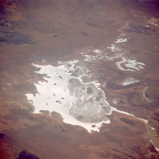 |
| STS008-48-2510 Lake Disappointment, Western Australia, Australia September 1983 Lake Disappointment is an irregularly shaped dry lake that is located in north central Western Australia. The lake covers approximately 370650 acres (150000 ha) and is fed by the Savory Creek (not discernible on this image) that feeds into the northwest side of the lake. Lake Disappointment lies at the lowest point in a large basin (the Little Sandy Desert bioregion) of exposed sandstone. Evaporation rates far exceed the meager rainfall amount--mean annual rainfall is 7.5 inches (190 mm). Sand dunes on the lake form islands rising 16-60 feet (5-18 meters) above the bed. Notice the eastern half of the lake is darker in color, indicating that the elevation of the land is probably somewhat higher with more vegetative cover than the highly reflective western side of the lake. The lake was named in 1897 by explorer F. H. Hann who was searching for fresh water but was disappointed when he discovered that the lake was saline. |
| Images: | All Available Images Low-Resolution 295k |
|
| Mission: | STS008 |
|
| Roll - Frame: | 48 - 2510 |
|
| Geographical Name: | AUSTRALIA-WA |
|
| Features: | LAKE DISAPPOINTMENT |
|
| Center Lat x Lon: | 23.5S x 123.0E |
|
| Film Exposure: | N | N=Normal exposure, U=Under exposed, O=Over exposed, F=out of Focus |
| Percentage of Cloud Cover-CLDP: | 0 |
|
| Camera:: | HB |
|
| Camera Tilt: | LO | LO=Low Oblique, HO=High Oblique, NV=Near Vertical |
| Camera Focal Length: | 250 |
|
| Nadir to Photo Center Direction: | The direction from the nadir to the center point, N=North, S=South, E=East, W=West |
|
| Stereo?: | Y | Y=Yes there is an adjacent picture of the same area, N=No there isn't |
| Orbit Number: | 95 |
|
| Date: | 1983____ | YYYYMMDD |
| Time: | GMT HHMMSS |
|
| Nadir Lat: | N |
Latitude of suborbital point of spacecraft |
| Nadir Lon: | E |
Longitude of suborbital point of spacecraft |
| Sun Azimuth: | Clockwise angle in degrees from north to the sun measured at the nadir point |
|
| Space Craft Altitude: | nautical miles |
|
| Sun Elevation: | Angle in degrees between the horizon and the sun, measured at the nadir point |
|
| Land Views: | DESERT |
|
| Water Views: | RIVER, PLAYA |
|
| Atmosphere Views: | |
|
| Man Made Views: | |
|
| City Views: | |
|
Photo is not associated with any sequences | ||
| NASA Home Page |
JSC Home Page |
JSC Digital Image Collection |
Earth Science & Remote Sensing |
|
This service is provided by the International Space Station program and the JSC Earth Science & Remote Sensing Unit, ARES Division, Exploration Integration Science Directorate.

|