
Geographic Region: AUSTRALIA-NT
Feature: REYNOLDS RANGES,LANDER R
|
Geographic Region: AUSTRALIA-NT Feature: REYNOLDS RANGES,LANDER R |
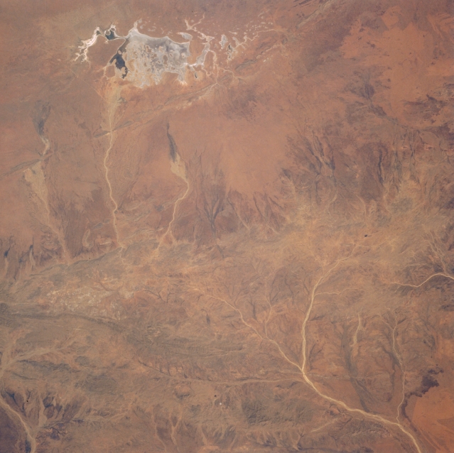 |
| STS008-43-2172 Reynolds Ranges, Northern Territory, Australia September 1983 Located north of the Macdonnell Mountain Ranges in south central Northern Territory, two smaller ranges are barely discernible in this low oblique, southwest looking picture. Drainage patterns (lighter-colored, linear features) that only intermittently carry water in this desert environment can be traced across the landscape from the flanks of the Reynolds Ranges (northwest-southeast aligned feature near center of image) as some creeks flow north and others flow generally to the south. The Stuart Bluff Range is a very narrow ridgeline that can be identified immediately north of the dry lakebed (highly reflective feature at the top of the image). The small, dark areas within the dry lake suggest that some type of plant life exists at the time this picture was acquired. The very dark area near the eastern margin of the dry lake may be standing water. |
| Images: | All Available Images Low-Resolution 291k |
|
| Mission: | STS008 |
|
| Roll - Frame: | 43 - 2172 |
|
| Geographical Name: | AUSTRALIA-NT |
|
| Features: | REYNOLDS RANGES,LANDER R |
|
| Center Lat x Lon: | 22.5S x 132.5E |
|
| Film Exposure: | N | N=Normal exposure, U=Under exposed, O=Over exposed, F=out of Focus |
| Percentage of Cloud Cover-CLDP: | 0 |
|
| Camera:: | HB |
|
| Camera Tilt: | LO | LO=Low Oblique, HO=High Oblique, NV=Near Vertical |
| Camera Focal Length: | 100 |
|
| Nadir to Photo Center Direction: | The direction from the nadir to the center point, N=North, S=South, E=East, W=West |
|
| Stereo?: | Y | Y=Yes there is an adjacent picture of the same area, N=No there isn't |
| Orbit Number: | 95 |
|
| Date: | 1983____ | YYYYMMDD |
| Time: | GMT HHMMSS |
|
| Nadir Lat: | N |
Latitude of suborbital point of spacecraft |
| Nadir Lon: | E |
Longitude of suborbital point of spacecraft |
| Sun Azimuth: | Clockwise angle in degrees from north to the sun measured at the nadir point |
|
| Space Craft Altitude: | nautical miles |
|
| Sun Elevation: | Angle in degrees between the horizon and the sun, measured at the nadir point |
|
| Land Views: | MOUNTAIN |
|
| Water Views: | RIVER, PLAYA |
|
| Atmosphere Views: | |
|
| Man Made Views: | |
|
| City Views: | |
|
Photo is not associated with any sequences | ||
| NASA Home Page |
JSC Home Page |
JSC Digital Image Collection |
Earth Science & Remote Sensing |
|
This service is provided by the International Space Station program and the JSC Earth Science & Remote Sensing Unit, ARES Division, Exploration Integration Science Directorate.

|