Geographic Region: BOTSWANA
Feature: ZAMBEZI & CHOBE RIVER
|
Geographic Region: BOTSWANA Feature: ZAMBEZI & CHOBE RIVER |
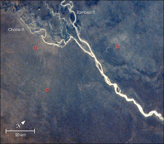 |
| At the junction of the Chobe and Zambezi Rivers, Botswana, increasing elephant populations are having large impacts on local vegetation. Scientists working in the region used spectral analysis of an astronaut photograph digitized from film to identify areas where woodland vegetation had been heavily damaged by the elephants. The technique used the analysis of texture of the red band (or channel) in the image. In the image above, the natural color photo has been combined with a texture analysis of the red band. The lighter colored areas near the labels a, b and c represent the areas with the heaviest elephant damage. Field teams working on the ground verified the presence of damage. This image is one of the examples of the applications of astronaut photography to conservation biology presented in a paper by Robinson et al. in the August 2001 issue of the scientific journal Conservation Biology. The paper is part of a special section on "Contributions of Remote Sensing to Biodiversity Conservation" (//www.conbio.org/scb/Services/Tips/2001-4-August.cfm) featuring a number of different NASA-sponsored studies. |
| Images: | All Available Images Low-Resolution 65k |
|
| Mission: | STS008 |
|
| Roll - Frame: | 33 - 993 |
|
| Geographical Name: | BOTSWANA |
|
| Features: | ZAMBEZI & CHOBE RIVER |
|
| Center Lat x Lon: | 18S x 25.0E |
|
| Film Exposure: | N | N=Normal exposure, U=Under exposed, O=Over exposed, F=out of Focus |
| Percentage of Cloud Cover-CLDP: | 0 |
|
| Camera:: | HB |
|
| Camera Tilt: | LO | LO=Low Oblique, HO=High Oblique, NV=Near Vertical |
| Camera Focal Length: | 100 |
|
| Nadir to Photo Center Direction: | The direction from the nadir to the center point, N=North, S=South, E=East, W=West |
|
| Stereo?: | Y | Y=Yes there is an adjacent picture of the same area, N=No there isn't |
| Orbit Number: | 33 |
|
| Date: | 1983____ | YYYYMMDD |
| Time: | GMT HHMMSS |
|
| Nadir Lat: | N |
Latitude of suborbital point of spacecraft |
| Nadir Lon: | E |
Longitude of suborbital point of spacecraft |
| Sun Azimuth: | Clockwise angle in degrees from north to the sun measured at the nadir point |
|
| Space Craft Altitude: | nautical miles |
|
| Sun Elevation: | Angle in degrees between the horizon and the sun, measured at the nadir point |
|
| Land Views: | |
|
| Water Views: | RIVER |
|
| Atmosphere Views: | |
|
| Man Made Views: | |
|
| City Views: | |
|
Photo is not associated with any sequences | ||
| NASA Home Page |
JSC Home Page |
JSC Digital Image Collection |
Earth Science & Remote Sensing |
|
This service is provided by the International Space Station program and the JSC Earth Science & Remote Sensing Unit, ARES Division, Exploration Integration Science Directorate.

|