Geographic Region: MADAGASCAR
Feature: BETSIBOKA RIVER DELTA
|
Geographic Region: MADAGASCAR Feature: BETSIBOKA RIVER DELTA |
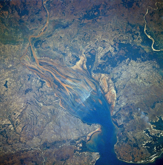 |
| STS007-03-0058 Betsiboka River Delta, Madagascar June 1983 Dramatic evidence of the catastrophic erosion of northwestern Madagascar is revealed in this near-vertical, June 1983 photograph of the rapidly expanding Betsiboka River Delta. The removal of the native forest for cultivation and pastureland during the past 50 years has led to massive annual soil losses approaching 112 tons per acre (250 metric tons per hectare) in some regions of the island, the largest amount recorded anywhere in the world. The photograph provides convincing evidence of the result of this process, as the effects of water erosion are seen throughout the 1544-square-mile (4000-square-kilometer) land surface area of the photograph. The delta continues to build toward the mouth of Bombetoka Bay, which enters the Mozambique Channel. As a result of rapid and unregulated deforestation, the eroded watershed of the Betsiboka River in NW Madagascar (16.0N, 46.5E) debouches into a large estuary, the Bay of Bombeteka. The immense sediment loads coming down the river have resulted in the silting of of the estuary since 1947 when the port facility of Majunga was moved from inland to the coast to prevent oceangoing ships from running aground. |
| Images: | All Available Images Low-Resolution 409k |
|
| Mission: | STS007 |
|
| Roll - Frame: | 3 - 58 |
|
| Geographical Name: | MADAGASCAR |
|
| Features: | BETSIBOKA RIVER DELTA |
|
| Center Lat x Lon: | 16S x 46.5E |
|
| Film Exposure: | N | N=Normal exposure, U=Under exposed, O=Over exposed, F=out of Focus |
| Percentage of Cloud Cover-CLDP: | 0 |
|
| Camera:: | HB |
|
| Camera Tilt: | NV | LO=Low Oblique, HO=High Oblique, NV=Near Vertical |
| Camera Focal Length: | 250 |
|
| Nadir to Photo Center Direction: | The direction from the nadir to the center point, N=North, S=South, E=East, W=West |
|
| Stereo?: | Y | Y=Yes there is an adjacent picture of the same area, N=No there isn't |
| Orbit Number: | 16 |
|
| Date: | 198306__ | YYYYMMDD |
| Time: | GMT HHMMSS |
|
| Nadir Lat: | N |
Latitude of suborbital point of spacecraft |
| Nadir Lon: | E |
Longitude of suborbital point of spacecraft |
| Sun Azimuth: | Clockwise angle in degrees from north to the sun measured at the nadir point |
|
| Space Craft Altitude: | nautical miles |
|
| Sun Elevation: | Angle in degrees between the horizon and the sun, measured at the nadir point |
|
| Land Views: | BASIN, HILL, COAST |
|
| Water Views: | BAY, CHANNEL, DELTA, RIVER, SEDIMENT, ESTUARY |
|
| Atmosphere Views: | |
|
| Man Made Views: | DEFORESTATION |
|
| City Views: | |
|
Photo is not associated with any sequences | ||
| NASA Home Page |
JSC Home Page |
JSC Digital Image Collection |
Earth Science & Remote Sensing |
|
This service is provided by the International Space Station program and the JSC Earth Science & Remote Sensing Unit, ARES Division, Exploration Integration Science Directorate.

|