
Geographic Region: USA-NEW MEXICO
Feature: WHITE SANDS
|
Geographic Region: USA-NEW MEXICO Feature: WHITE SANDS |
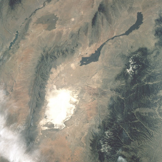 |
| STS003-10-0613 White Sands, New Mexico, U.S.A March 1982White Sands, a region of sand dunes made white by their high gypsum content in south-central New Mexico, is seen in this low-oblique, north-looking photograph. This is an alternate Shuttle landing site (in fact, STS-003 landed here). North of White Sands in the same valley between the San Andres Mountains on the west and the Sacramento Mountains on the east, two long, narrow, young lava flows emanate in separate directions from a fissure that is not discernible on the photograph. One can observe the Rio Grande rift system along the western edge of this photograph. Elephant Butte Reservoir is the elongated dark feature within the rift valley. The areas that appear as white circles south and west of the lava flows were cleared for possible use as sites for atomic weapons testing during World War II. A truly remarkable view of White Sands and the nearby Carrizozo Lava Beds in southeast NM (33.5N, 106.5W). White Sands, site of the WW II atomic bomb development and testing facility and later post war nuclear weapons testing that can still be seen in the cleared circular patterns on the ground. Space Shuttle Columbia, this mission, landed at the White Sands alternate landing site because of bad weather at Edwards AFB, CA. |
| Images: | All Available Images Low-Resolution 153k |
|
| Mission: | STS003 |
|
| Roll - Frame: | 10 - 613 |
|
| Geographical Name: | USA-NEW MEXICO |
|
| Features: | WHITE SANDS |
|
| Center Lat x Lon: | 33.0N x 106W |
|
| Film Exposure: | N | N=Normal exposure, U=Under exposed, O=Over exposed, F=out of Focus |
| Percentage of Cloud Cover-CLDP: | 10 |
|
| Camera:: | HB |
|
| Camera Tilt: | NV | LO=Low Oblique, HO=High Oblique, NV=Near Vertical |
| Camera Focal Length: | 100 |
|
| Nadir to Photo Center Direction: | The direction from the nadir to the center point, N=North, S=South, E=East, W=West |
|
| Stereo?: | Y | Y=Yes there is an adjacent picture of the same area, N=No there isn't |
| Orbit Number: | |
|
| Date: | 198203__ | YYYYMMDD |
| Time: | GMT HHMMSS |
|
| Nadir Lat: | N |
Latitude of suborbital point of spacecraft |
| Nadir Lon: | E |
Longitude of suborbital point of spacecraft |
| Sun Azimuth: | Clockwise angle in degrees from north to the sun measured at the nadir point |
|
| Space Craft Altitude: | nautical miles |
|
| Sun Elevation: | Angle in degrees between the horizon and the sun, measured at the nadir point |
|
| Land Views: | DESERT, MOUNTAIN, VOLCANO, BASIN |
|
| Water Views: | RIVER, RESERVOIR |
|
| Atmosphere Views: | |
|
| Man Made Views: | URBAN AREA |
|
| City Views: | |
|
Photo is not associated with any sequences | ||
| NASA Home Page |
JSC Home Page |
JSC Digital Image Collection |
Earth Science & Remote Sensing |
|
This service is provided by the International Space Station program and the JSC Earth Science & Remote Sensing Unit, ARES Division, Exploration Integration Science Directorate.

|