
Geographic Region: GERMANY
Feature: MUNICH
|
Geographic Region: GERMANY Feature: MUNICH |
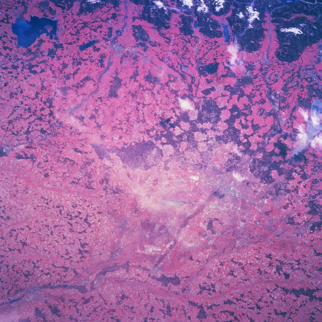 |
| NM23-777-730 Munich (Munchen), Germany Winter/Spring 1997 The location of Munich, the largest city in southeast Germany, is partially obscured by a wispy cloud (slightly below center of image). The main channel (linear feature) of the northeasterly draining Iscar River is discernible as the river passes through Munich and as the river passes just to the west of the dual runways (light colored, parallel lines) of the Munich airport which is visible northeast of Munich (bottom center of image). Much of the landscape in this color infrared image is the result of glacial deposits from the Alps to the south. The pockmarked landscape (dark reds with oval-shaped lighter areas) immediately south of the urban area is a mixture of forested lands (dark reds) and lands cleared for agriculture. This region, also known as the Alpine Foreland, is geographically strategic because of its excellent piedmont location for both east-west and north-south traffic. The medieval character of the Munich area has continued to flourish and has turned the region into a center of prominence for tourism from Germany as well as from throughout the world. The large dark feature in the upper left corner of the image is Lake Chiem. The cluster of the dark features (top right), are the forested, leading edges of the beautiful Bavarian Alps (note snow cover on the higher elevations). |
| Images: | All Available Images Low-Resolution 418k |
|
| Mission: | NM23 |
|
| Roll - Frame: | 777 - 730 |
|
| Geographical Name: | GERMANY |
|
| Features: | MUNICH |
|
| Center Lat x Lon: | 48.0N x 11.5E |
|
| Film Exposure: | N | N=Normal exposure, U=Under exposed, O=Over exposed, F=out of Focus |
| Percentage of Cloud Cover-CLDP: | 5 |
|
| Camera:: | HB |
|
| Camera Tilt: | LO | LO=Low Oblique, HO=High Oblique, NV=Near Vertical |
| Camera Focal Length: | 100 |
|
| Nadir to Photo Center Direction: | W | The direction from the nadir to the center point, N=North, S=South, E=East, W=West |
| Stereo?: | Y | Y=Yes there is an adjacent picture of the same area, N=No there isn't |
| Orbit Number: | 999 |
|
| Date: | 19970503 | YYYYMMDD |
| Time: | 124150 | GMT HHMMSS |
| Nadir Lat: | 47.9N |
Latitude of suborbital point of spacecraft |
| Nadir Lon: | 17.6E |
Longitude of suborbital point of spacecraft |
| Sun Azimuth: | 226 | Clockwise angle in degrees from north to the sun measured at the nadir point |
| Space Craft Altitude: | 210 | nautical miles |
| Sun Elevation: | 50 | Angle in degrees between the horizon and the sun, measured at the nadir point |
| Land Views: | FOREST, MOUNTAIN |
|
| Water Views: | RIVER, LAKE |
|
| Atmosphere Views: | |
|
| Man Made Views: | |
|
| City Views: | |
|
Photo is not associated with any sequences | ||
| NASA Home Page |
JSC Home Page |
JSC Digital Image Collection |
Earth Science & Remote Sensing |
|
This service is provided by the International Space Station program and the JSC Earth Science & Remote Sensing Unit, ARES Division, Exploration Integration Science Directorate.

|