
Geographic Region: GERMANY
Feature: RHINE RIVER
|
Geographic Region: GERMANY Feature: RHINE RIVER |
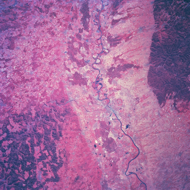 |
| NM23-777-722 Rhine (Rhein) River, Germany Winter/Spring 1997 A section of the Rhine River Valley in southwest Germany is visible in the center of this color infrared image as the river drains northward (top to bottom). The main channel of the river is discernible as a series of loops (meander scars and oxbow lakes) south of the center of the picture and a winding, dark line north of the center of the picture. The Neckar River, a tributary of the Rhine, is visible (thin, dark line) as it enters the Rhine slightly below the center of the image. The pronounced dark red area (upper right) is part of a dense, forested landscape with a well-defined escarpment along its eastern edge. This escarpment also marks the western edge of the Rhine River floodplain. While the eastern boundary of the Rhine River floodplain is less well defined, a linear color change (from lighter colors to a lighter red) can be discerned extending vertically through part of the image. In general the darker reds show undeveloped, forested lands and the other colors represent a variety of agricultural activity that includes mixed crops and fruit orchards. |
| Images: | All Available Images Low-Resolution 410k |
|
| Mission: | NM23 |
|
| Roll - Frame: | 777 - 722 |
|
| Geographical Name: | GERMANY |
|
| Features: | RHINE RIVER |
|
| Center Lat x Lon: | 49.5N x 8.5E |
|
| Film Exposure: | N | N=Normal exposure, U=Under exposed, O=Over exposed, F=out of Focus |
| Percentage of Cloud Cover-CLDP: | 0 |
|
| Camera:: | HB |
|
| Camera Tilt: | LO | LO=Low Oblique, HO=High Oblique, NV=Near Vertical |
| Camera Focal Length: | 100 |
|
| Nadir to Photo Center Direction: | W | The direction from the nadir to the center point, N=North, S=South, E=East, W=West |
| Stereo?: | Y | Y=Yes there is an adjacent picture of the same area, N=No there isn't |
| Orbit Number: | 999 |
|
| Date: | 19970503 | YYYYMMDD |
| Time: | 124115 | GMT HHMMSS |
| Nadir Lat: | 48.8N |
Latitude of suborbital point of spacecraft |
| Nadir Lon: | 14.6E |
Longitude of suborbital point of spacecraft |
| Sun Azimuth: | 222 | Clockwise angle in degrees from north to the sun measured at the nadir point |
| Space Craft Altitude: | 210 | nautical miles |
| Sun Elevation: | 51 | Angle in degrees between the horizon and the sun, measured at the nadir point |
| Land Views: | VALLEY, FOREST, PLAIN |
|
| Water Views: | RIVER |
|
| Atmosphere Views: | |
|
| Man Made Views: | |
|
| City Views: | |
|
Photo is not associated with any sequences | ||
| NASA Home Page |
JSC Home Page |
JSC Digital Image Collection |
Earth Science & Remote Sensing |
|
This service is provided by the International Space Station program and the JSC Earth Science & Remote Sensing Unit, ARES Division, Exploration Integration Science Directorate.

|