
Geographic Region: ITALY
Feature: MILAN, LAKES
|
Geographic Region: ITALY Feature: MILAN, LAKES |
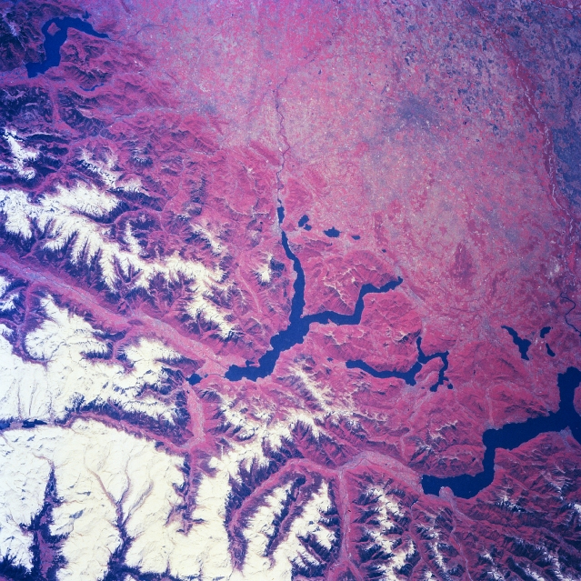 |
| NM23-776-834 Italian Alps, Italy Winter/Spring 1997 Several elongated lakes (dark features) are identifiable in this southerly view of the Italian-Swiss border. The elongated lakes are the creation of alpine (or valley) glaciers that moved generally southward through this section of the Italian Alps over 12000 years ago. From west to east the four larger lakes are Maggiore (lower right corner), Lugana, Como, and d'Iseo (upper left corner). Smaller lakes (also dark features) are visible at the southern end of Lake Como (center of image) and Lake Maggiore. Subtle faults that are perpendicular to the southern end of the lakes can be traced east to west across the landscape at the base of the Italian Alps. Glaciated, U-shaped valleys are discernible north and northeast of the lakes. The color infrared helps to identify the densely vegetated mountain slopes where the forested land (green vegetation) is shown as concentrations of reddish patterns. The relatively flat plains of the highly industrialized and agriculturally productive Po River Valley (upper third of image) presents a dramatically different looking terrain than the snow covered mountainous region of northern Italy. |
| Images: | All Available Images Low-Resolution 416k |
|
| Mission: | NM23 |
|
| Roll - Frame: | 776 - 834 |
|
| Geographical Name: | ITALY |
|
| Features: | MILAN, LAKES |
|
| Center Lat x Lon: | 45.5N x 10.0E |
|
| Film Exposure: | N | N=Normal exposure, U=Under exposed, O=Over exposed, F=out of Focus |
| Percentage of Cloud Cover-CLDP: | 0 |
|
| Camera:: | HB |
|
| Camera Tilt: | 52 | LO=Low Oblique, HO=High Oblique, NV=Near Vertical |
| Camera Focal Length: | 250 |
|
| Nadir to Photo Center Direction: | S | The direction from the nadir to the center point, N=North, S=South, E=East, W=West |
| Stereo?: | Y | Y=Yes there is an adjacent picture of the same area, N=No there isn't |
| Orbit Number: | 999 |
|
| Date: | 19970505 | YYYYMMDD |
| Time: | 090948 | GMT HHMMSS |
| Nadir Lat: | 49.9N |
Latitude of suborbital point of spacecraft |
| Nadir Lon: | 9.3E |
Longitude of suborbital point of spacecraft |
| Sun Azimuth: | 130 | Clockwise angle in degrees from north to the sun measured at the nadir point |
| Space Craft Altitude: | 208 | nautical miles |
| Sun Elevation: | 48 | Angle in degrees between the horizon and the sun, measured at the nadir point |
| Land Views: | MOUNTAIN, PLAIN |
|
| Water Views: | LAKE, RIVER |
|
| Atmosphere Views: | |
|
| Man Made Views: | |
|
| City Views: | |
|
Photo is not associated with any sequences | ||
| NASA Home Page |
JSC Home Page |
JSC Digital Image Collection |
Earth Science & Remote Sensing |
|
This service is provided by the International Space Station program and the JSC Earth Science & Remote Sensing Unit, ARES Division, Exploration Integration Science Directorate.

|