
Geographic Region: FRANCE
Feature: LAKE GENEVA
|
Geographic Region: FRANCE Feature: LAKE GENEVA |
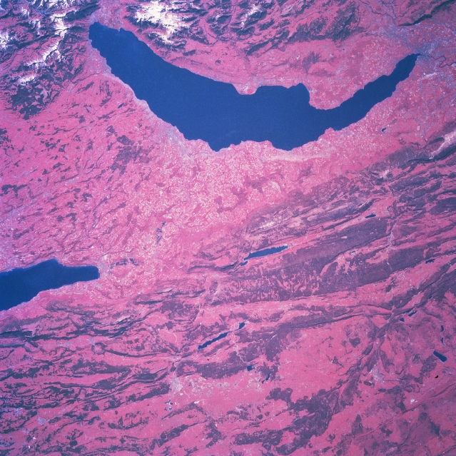 |
| NM23-776-820 Lake Geneva Area, Switzerland Winter/Spring 1997 The western end of Switzerland, including all of Lake Geneva (crescent-shaped, dark feature) is visible in this color infrared image (green vegetation is presented in red colors) that looks south towards the Alps. A small part of the snow capped Swiss Alps (upper left) and the French Alps (upper middle) can be seen along the top margin of the picture. The Swiss city of Geneva is located at the southwest end (upper right) of Lake Geneva. The light-colored, linear feature north of the city is Geneva International Airport. The Jura Mountains, genetically part of the Alpine System, of northwest Switzerland (darker swaths of red) resemble the folded Appalachian System of mountains in the eastern United States. Synclinal valleys are separated by anticlinal ridges but are joined by narrow gorges. The deeper reds represent the green foliage of the forests in this color infrared image, accentuating the parallel, linear-looking ridgelines. The wide basins between some of the ridges are mainly grasslands. The eastern end (lower center) of the Jura Mountains offers a much easier ground route than the rest of the mountains which are a barrier to ground transportation. Tunnels have been cut through the Jura Mountains to permit surface connections between northwestern Europe and Italy. |
| Images: | All Available Images Low-Resolution 403k |
|
| Mission: | NM23 |
|
| Roll - Frame: | 776 - 820 |
|
| Geographical Name: | FRANCE |
|
| Features: | LAKE GENEVA |
|
| Center Lat x Lon: | 47.0N x 6.0E |
|
| Film Exposure: | N | N=Normal exposure, U=Under exposed, O=Over exposed, F=out of Focus |
| Percentage of Cloud Cover-CLDP: | 0 |
|
| Camera:: | HB |
|
| Camera Tilt: | 33 | LO=Low Oblique, HO=High Oblique, NV=Near Vertical |
| Camera Focal Length: | 250 |
|
| Nadir to Photo Center Direction: | S | The direction from the nadir to the center point, N=North, S=South, E=East, W=West |
| Stereo?: | Y | Y=Yes there is an adjacent picture of the same area, N=No there isn't |
| Orbit Number: | 999 |
|
| Date: | 19970505 | YYYYMMDD |
| Time: | 090900 | GMT HHMMSS |
| Nadir Lat: | 49.0N |
Latitude of suborbital point of spacecraft |
| Nadir Lon: | 5.0E |
Longitude of suborbital point of spacecraft |
| Sun Azimuth: | 124 | Clockwise angle in degrees from north to the sun measured at the nadir point |
| Space Craft Altitude: | 207 | nautical miles |
| Sun Elevation: | 46 | Angle in degrees between the horizon and the sun, measured at the nadir point |
| Land Views: | MOUNTAIN, VALLEY |
|
| Water Views: | LAKE |
|
| Atmosphere Views: | |
|
| Man Made Views: | |
|
| City Views: | |
|
Photo is not associated with any sequences | ||
| NASA Home Page |
JSC Home Page |
JSC Digital Image Collection |
Earth Science & Remote Sensing |
|
This service is provided by the International Space Station program and the JSC Earth Science & Remote Sensing Unit, ARES Division, Exploration Integration Science Directorate.

|