
Geographic Region: SPAIN
Feature: RIO EBRO DELTA
|
Geographic Region: SPAIN Feature: RIO EBRO DELTA |
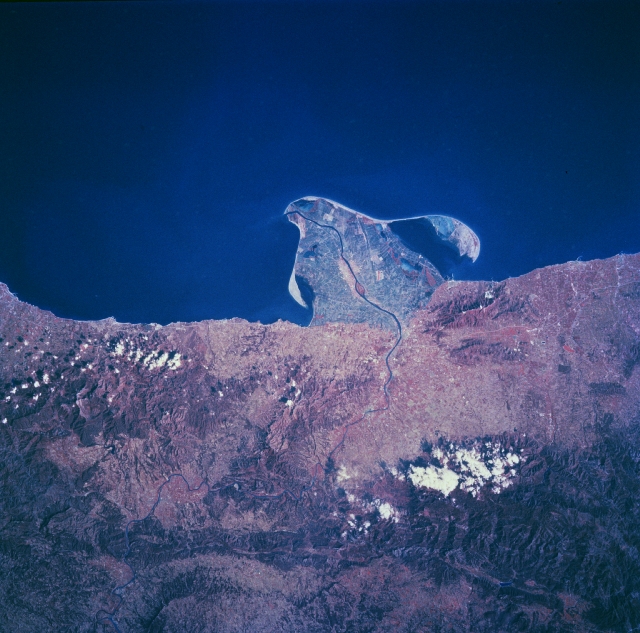 |
| NM23-776-760 Ebro River Delta, Spain Winter/Spring 1997 Southwest of Barcelona along the east coast of Spain, the Ebro River has created a uniquely shaped delta that protrudes into the Mediterranean Sea. The thin, winding dark line (center of the image) is the main channel of the Ebro River. The island of Buda, located at the mouth of the river and on the south side of the main channel on the Ebro, is part of the Ebro Delta Nature Park. The delta is one of the major wetlands along the east coast of Spain. A great diversity of animal habitats presently exists in this environmentally sensitive delta. The construction of many dams inland within the Ebro River Basin has already reduced the flow of water through the delta, thereby reducing the natural silt deposition and retarding future growth of the delta into the Mediterranean Sea. By constructing numerous canals and irrigation ditches that crisscross the delta, conservationists and agricultural operators alike have contributed to and benefited from the effective management and use of the delta. The color infrared film helps to identify the land-water boundaries and the swath of deeper reds (vegetated landscape) inland from the coast show the mountains that parallel the coast, known as the Catalonian Range. |
| Images: | All Available Images Low-Resolution 334k |
|
| Mission: | NM23 |
|
| Roll - Frame: | 776 - 760 |
|
| Geographical Name: | SPAIN |
|
| Features: | RIO EBRO DELTA |
|
| Center Lat x Lon: | 40.5N x .5E |
|
| Film Exposure: | N | N=Normal exposure, U=Under exposed, O=Over exposed, F=out of Focus |
| Percentage of Cloud Cover-CLDP: | 5 |
|
| Camera:: | HB |
|
| Camera Tilt: | 33 | LO=Low Oblique, HO=High Oblique, NV=Near Vertical |
| Camera Focal Length: | 100 |
|
| Nadir to Photo Center Direction: | NE | The direction from the nadir to the center point, N=North, S=South, E=East, W=West |
| Stereo?: | N | Y=Yes there is an adjacent picture of the same area, N=No there isn't |
| Orbit Number: | 999 |
|
| Date: | 19970504 | YYYYMMDD |
| Time: | 145518 | GMT HHMMSS |
| Nadir Lat: | 38.8N |
Latitude of suborbital point of spacecraft |
| Nadir Lon: | 1W |
Longitude of suborbital point of spacecraft |
| Sun Azimuth: | 252 | Clockwise angle in degrees from north to the sun measured at the nadir point |
| Space Craft Altitude: | 211 | nautical miles |
| Sun Elevation: | 46 | Angle in degrees between the horizon and the sun, measured at the nadir point |
| Land Views: | PENINSULA, MOUNTAIN |
|
| Water Views: | DELTA, RIVER |
|
| Atmosphere Views: | |
|
| Man Made Views: | |
|
| City Views: | |
|
Photo is not associated with any sequences | ||
| NASA Home Page |
JSC Home Page |
JSC Digital Image Collection |
Earth Science & Remote Sensing |
|
This service is provided by the International Space Station program and the JSC Earth Science & Remote Sensing Unit, ARES Division, Exploration Integration Science Directorate.

|