
Geographic Region: PARAGUAY
Feature: RIO PARANA, SMOKE
|
Geographic Region: PARAGUAY Feature: RIO PARANA, SMOKE |
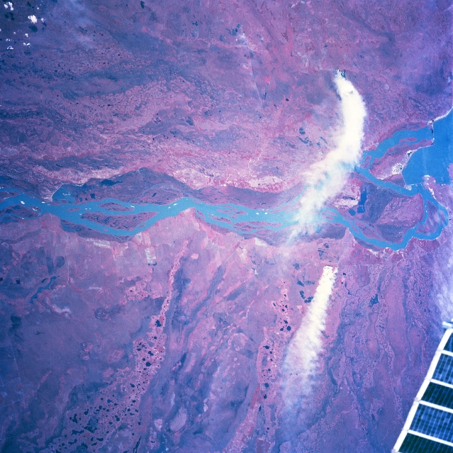 |
| NM23-773-056 Rio Parana, Argentina/Paraguay Winter/Spring 1997 For geographic reference the Yacyreta-Apipe Dams are visible on the Rio Parana near the eastern edge of the picture (right margin). The Rio Parana is the border between Paraguay (top) and Argentina (bottom). In addition to the well-defined, natural floodplain of the Rio Parana (darker feature, mainly on the Paraguay side of the river), the entire scene shows a complex hydrologic pattern. Complicated and intricate drainage patterns can be observed on both sides of the river. It appears that the Rio Parana has repeatedly made significant course changes. South of the river, well defined, older drainage channels, primarily aligned in a northeast-southwest pattern, can be traced across this flat, swampy terrain. North of the Rio Parana in Paraguay the older drainage channels are aligned more east-west. Two large smoke plumes (white features-one originating in Paraguay, the other in Argentina) appear on the right side. A small section (solar array truss) of the Space Station Mir is visible in the lower right corner of the picture. |
| Images: | All Available Images Low-Resolution 376k |
|
| Mission: | NM23 |
|
| Roll - Frame: | 773 - 56 |
|
| Geographical Name: | PARAGUAY |
|
| Features: | RIO PARANA, SMOKE |
|
| Center Lat x Lon: | 27.5S x 57.5W |
|
| Film Exposure: | N | N=Normal exposure, U=Under exposed, O=Over exposed, F=out of Focus |
| Percentage of Cloud Cover-CLDP: | 5 |
|
| Camera:: | HB |
|
| Camera Tilt: | LO | LO=Low Oblique, HO=High Oblique, NV=Near Vertical |
| Camera Focal Length: | 250 |
|
| Nadir to Photo Center Direction: | The direction from the nadir to the center point, N=North, S=South, E=East, W=West |
|
| Stereo?: | Y | Y=Yes there is an adjacent picture of the same area, N=No there isn't |
| Orbit Number: | |
|
| Date: | 19970320 | YYYYMMDD |
| Time: | GMT HHMMSS |
|
| Nadir Lat: | N |
Latitude of suborbital point of spacecraft |
| Nadir Lon: | E |
Longitude of suborbital point of spacecraft |
| Sun Azimuth: | Clockwise angle in degrees from north to the sun measured at the nadir point |
|
| Space Craft Altitude: | nautical miles |
|
| Sun Elevation: | Angle in degrees between the horizon and the sun, measured at the nadir point |
|
| Land Views: | FLOOD PLAIN |
|
| Water Views: | RIVER |
|
| Atmosphere Views: | SMOKE |
|
| Man Made Views: | |
|
| City Views: | |
|
Photo is not associated with any sequences | ||
| NASA Home Page |
JSC Home Page |
JSC Digital Image Collection |
Earth Science & Remote Sensing |
|
This service is provided by the International Space Station program and the JSC Earth Science & Remote Sensing Unit, ARES Division, Exploration Integration Science Directorate.

|