Geographic Region: CHILE
Feature: ANDES MOUNTAINS
|
Geographic Region: CHILE Feature: ANDES MOUNTAINS |
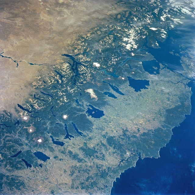 |
| NM23-764-236 Southern Andes Mountains, Central Valley, Chile Winter/Spring 1997 Many volcanic peaks, snowcapped ridges and glacial lakes of the southern Andes Mountains are visible in this southeast-looking view. Between the mountains and the Pacific Ocean (lower right), the long, narrow, fertile Central Valley of Chile appears distinctly greener--on the wet side of the mountains--compared with the dry plains of Patagonia (top left). The Central Valley stretches southward to where it drops below sea level into the Gulf of Ancud (upper right). The glacial lakes of the forested slopes of the Andes begin with Lakes Colico, Caburgua, and Villarrica (bottom left portion of the image). Between Lakes Villarrica and Calafquen is the snow-covered stratovolcano Villarrica, which is active at this writing. The large lake with the small island near its center is Lake Ranco. Just to the south-southeast of Lake Ranco and at the center of the image is the Cordillera Nevada. The narrow complex lake on the Patagonian side of the Cordillera Nevada is Lake Nahuel Huapi. The large lake at the southern end of the Central Valley is Llanquihue. Chile's major southern port of Puerto Montt is the small white patch at the north end of the Bay of Seno de Reloncavi (just south of Lake Llanquihue). Covering the upper left and top center of the image is the Patagonian Plateau. |
| Images: | All Available Images Low-Resolution 403k |
|
| Mission: | NM23 |
|
| Roll - Frame: | 764 - 236 |
|
| Geographical Name: | CHILE |
|
| Features: | ANDES MOUNTAINS |
|
| Center Lat x Lon: | 40.5S x 72.5W |
|
| Film Exposure: | N | N=Normal exposure, U=Under exposed, O=Over exposed, F=out of Focus |
| Percentage of Cloud Cover-CLDP: | 0 |
|
| Camera:: | HB |
|
| Camera Tilt: | LO | LO=Low Oblique, HO=High Oblique, NV=Near Vertical |
| Camera Focal Length: | 100 |
|
| Nadir to Photo Center Direction: | SW | The direction from the nadir to the center point, N=North, S=South, E=East, W=West |
| Stereo?: | Y | Y=Yes there is an adjacent picture of the same area, N=No there isn't |
| Orbit Number: | |
|
| Date: | 19970210 | YYYYMMDD |
| Time: | GMT HHMMSS |
|
| Nadir Lat: | N |
Latitude of suborbital point of spacecraft |
| Nadir Lon: | E |
Longitude of suborbital point of spacecraft |
| Sun Azimuth: | Clockwise angle in degrees from north to the sun measured at the nadir point |
|
| Space Craft Altitude: | nautical miles |
|
| Sun Elevation: | Angle in degrees between the horizon and the sun, measured at the nadir point |
|
| Land Views: | MOUNTAIN, PLATEAU, VALLEY, VOLCANO, FOREST |
|
| Water Views: | LAKE, GULF |
|
| Atmosphere Views: | |
|
| Man Made Views: | AGRICULTURE |
|
| City Views: | |
|
Photo is not associated with any sequences | ||
| NASA Home Page |
JSC Home Page |
JSC Digital Image Collection |
Earth Science & Remote Sensing |
|
This service is provided by the International Space Station program and the JSC Earth Science & Remote Sensing Unit, ARES Division, Exploration Integration Science Directorate.

|