Geographic Region: UK-ENGLAND
Feature: LONDON
|
Geographic Region: UK-ENGLAND Feature: LONDON |
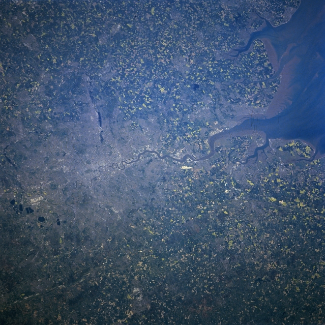 |
| NM23-762-213 Thames River, London, Great Britain Winter/Spring 1997 One of the great cities in the world and Great Britain's largest city, London, can be seen in this north-looking view. Located on both sides of the Thames River, 40 miles (64 km) from its mouth, and covering an area of over 622 sq. miles (1611 sq. km), London is a major political, financial, commercial, industrial, cultural, and transportation center. The city is one of the world's greatest ports exporting manufactured goods and importing petroleum, tea, wool, raw sugar, timber, meat, and metals. Tourism is a major industry. The Thames River is the principal river of England and is 210 miles (340 km) long. The lower Thames is a tidal estuary with the difference of 23 feet (7 meters) between low and high tide at London Bridge. The lower course of the river from London to its mouth is one of the most important industrial regions of Great Britain. Numerous agricultural field patterns surround the London Metropolitan area. |
| Images: | All Available Images Low-Resolution 390k |
|
| Mission: | NM23 |
|
| Roll - Frame: | 762 - 213 |
|
| Geographical Name: | UK-ENGLAND |
|
| Features: | LONDON |
|
| Center Lat x Lon: | 51.5N x .0E |
|
| Film Exposure: | N | N=Normal exposure, U=Under exposed, O=Over exposed, F=out of Focus |
| Percentage of Cloud Cover-CLDP: | 0 |
|
| Camera:: | HB |
|
| Camera Tilt: | 46 | LO=Low Oblique, HO=High Oblique, NV=Near Vertical |
| Camera Focal Length: | 100 |
|
| Nadir to Photo Center Direction: | NW | The direction from the nadir to the center point, N=North, S=South, E=East, W=West |
| Stereo?: | Y | Y=Yes there is an adjacent picture of the same area, N=No there isn't |
| Orbit Number: | 999 |
|
| Date: | 19970502 | YYYYMMDD |
| Time: | 133619 | GMT HHMMSS |
| Nadir Lat: | 49.6N |
Latitude of suborbital point of spacecraft |
| Nadir Lon: | 3.1E |
Longitude of suborbital point of spacecraft |
| Sun Azimuth: | 224 | Clockwise angle in degrees from north to the sun measured at the nadir point |
| Space Craft Altitude: | 210 | nautical miles |
| Sun Elevation: | 49 | Angle in degrees between the horizon and the sun, measured at the nadir point |
| Land Views: | PLAIN |
|
| Water Views: | RIVER, ESTUARY, SEDIMENT |
|
| Atmosphere Views: | |
|
| Man Made Views: | URBAN AREA, AGRICULTURE |
|
| City Views: | LONDON |
|
Photo is not associated with any sequences | ||
| NASA Home Page |
JSC Home Page |
JSC Digital Image Collection |
Earth Science & Remote Sensing |
|
This service is provided by the International Space Station program and the JSC Earth Science & Remote Sensing Unit, ARES Division, Exploration Integration Science Directorate.

|