Geographic Region: UK-ENGLAND
Feature: PLYMOUTH
|
Geographic Region: UK-ENGLAND Feature: PLYMOUTH |
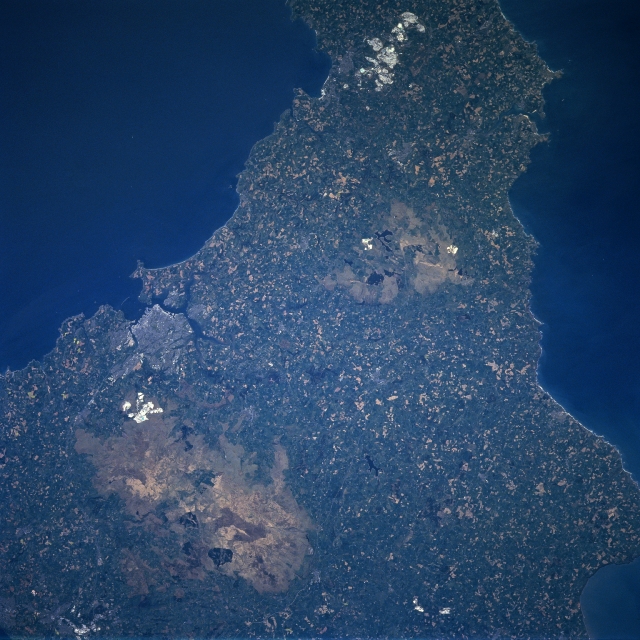 |
| NM23-762-206 Dartmoor, Plymouth, Great Britain Winter/Spring 1997 A portion of the southwestern peninsula of Great Britain is visible in this southwest-looking view. In the lower left part of the image, the upland region called Dartmoor can be seen. Dartmoor covers an area of 365 sq. miles (945 sq. km). It is a wasteland of bare granite peaks called tors that rise 1600-2000 feet (488-610 meters) in altitude. During the middle Ages, Dartmoor was an important tin-mining region. Dating back to the 12th century, china clay and granite have been mined from this region. Near the center of the image, the Bodmin Moor, another smaller upland region can be seen. Southwest of Dartmoor near the left center of the image, the large port city of Plymouth can be identified. Located on Plymouth Sound on a peninsula between the estuaries of the Plym and Tamar Rivers, Plymouth is an important port and major naval base in Great Britain. The first English factory to make Chinese porcelain was established in Plymouth in 1768. |
| Images: | All Available Images Low-Resolution 357k |
|
| Mission: | NM23 |
|
| Roll - Frame: | 762 - 206 |
|
| Geographical Name: | UK-ENGLAND |
|
| Features: | PLYMOUTH |
|
| Center Lat x Lon: | 50.5N x 4W |
|
| Film Exposure: | N | N=Normal exposure, U=Under exposed, O=Over exposed, F=out of Focus |
| Percentage of Cloud Cover-CLDP: | 0 |
|
| Camera:: | HB |
|
| Camera Tilt: | LO | LO=Low Oblique, HO=High Oblique, NV=Near Vertical |
| Camera Focal Length: | 100 |
|
| Nadir to Photo Center Direction: | W | The direction from the nadir to the center point, N=North, S=South, E=East, W=West |
| Stereo?: | Y | Y=Yes there is an adjacent picture of the same area, N=No there isn't |
| Orbit Number: | 999 |
|
| Date: | 19970502 | YYYYMMDD |
| Time: | 133559 | GMT HHMMSS |
| Nadir Lat: | 49.9N |
Latitude of suborbital point of spacecraft |
| Nadir Lon: | 1.2E |
Longitude of suborbital point of spacecraft |
| Sun Azimuth: | 221 | Clockwise angle in degrees from north to the sun measured at the nadir point |
| Space Craft Altitude: | 210 | nautical miles |
| Sun Elevation: | 50 | Angle in degrees between the horizon and the sun, measured at the nadir point |
| Land Views: | UPLAND, PLAIN, PENINSULA, COAST |
|
| Water Views: | OCEAN |
|
| Atmosphere Views: | |
|
| Man Made Views: | URBAN AREA, MINING |
|
| City Views: | |
|
Photo is not associated with any sequences | ||
| NASA Home Page |
JSC Home Page |
JSC Digital Image Collection |
Earth Science & Remote Sensing |
|
This service is provided by the International Space Station program and the JSC Earth Science & Remote Sensing Unit, ARES Division, Exploration Integration Science Directorate.

|