
Geographic Region: USA-CALIFORNIA
Feature: SAN FRANCISCO
|
Geographic Region: USA-CALIFORNIA Feature: SAN FRANCISCO |
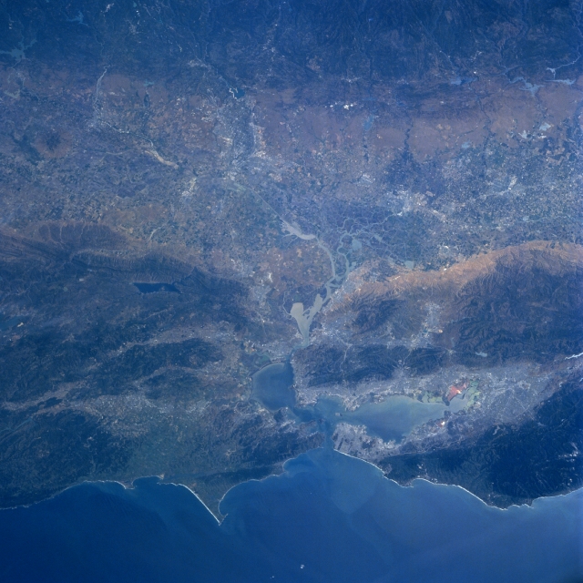 |
| NM23-761-742 Great Valley, California, USA Winter-Spring 1997 The major, lighter colored swath that extends laterally across the terrain (generally oriented northwest-southeast) is the central, low lying section of the Great Valley of California. The northern part of the valley is drained by the south-flowing Sacramento River and the southern part of the valley is drained by the north-flowing San Joaquin River. These rivers merge east of the San Francisco Bay area where they form a sizable delta, partially visible in this image. Even though the Great Valley receives limited precipitation (varies from 20 inches--7.8 centimeters--at the north end of the valley to 6 inches--2.3 centimeters--at the south end of the valley), an extensive irrigation network permits intensive agriculture throughout the valley. The darker landscape along the coast shows the extent of the forested Coastal Ranges that surrounds the San Francisco Bay area. Several major faults, including the San Andreas Fault (linear feature along west side of the bay) and the Hayward Fault (linear feature along east side of the bay) can be traced across this highly faulted and fractured region. The darker line towards the eastern edge of the picture (top) shows a series of parallel faults at the base of the foothills of the Sierra Nevada Mountains. Lake Berryessa (dark rectangular feature) is visible northeast of the bay area. |
| Images: | All Available Images Low-Resolution 330k |
|
| Mission: | NM23 |
|
| Roll - Frame: | 761 - 742 |
|
| Geographical Name: | USA-CALIFORNIA |
|
| Features: | SAN FRANCISCO |
|
| Center Lat x Lon: | 38.0N x 121.5W |
|
| Film Exposure: | N | N=Normal exposure, U=Under exposed, O=Over exposed, F=out of Focus |
| Percentage of Cloud Cover-CLDP: | 0 |
|
| Camera:: | HB |
|
| Camera Tilt: | LO | LO=Low Oblique, HO=High Oblique, NV=Near Vertical |
| Camera Focal Length: | 100 |
|
| Nadir to Photo Center Direction: | The direction from the nadir to the center point, N=North, S=South, E=East, W=West |
|
| Stereo?: | Y | Y=Yes there is an adjacent picture of the same area, N=No there isn't |
| Orbit Number: | |
|
| Date: | 199705__ | YYYYMMDD |
| Time: | GMT HHMMSS |
|
| Nadir Lat: | N |
Latitude of suborbital point of spacecraft |
| Nadir Lon: | E |
Longitude of suborbital point of spacecraft |
| Sun Azimuth: | Clockwise angle in degrees from north to the sun measured at the nadir point |
|
| Space Craft Altitude: | nautical miles |
|
| Sun Elevation: | Angle in degrees between the horizon and the sun, measured at the nadir point |
|
| Land Views: | VALLEY, MOUNTAIN, FAULT |
|
| Water Views: | BAY, DELTA |
|
| Atmosphere Views: | |
|
| Man Made Views: | |
|
| City Views: | |
|
Photo is not associated with any sequences | ||
| NASA Home Page |
JSC Home Page |
JSC Digital Image Collection |
Earth Science & Remote Sensing |
|
This service is provided by the International Space Station program and the JSC Earth Science & Remote Sensing Unit, ARES Division, Exploration Integration Science Directorate.

|