
Geographic Region: USA-NEW MEXICO
Feature: WHITE SANDS, EL PASO
|
Geographic Region: USA-NEW MEXICO Feature: WHITE SANDS, EL PASO |
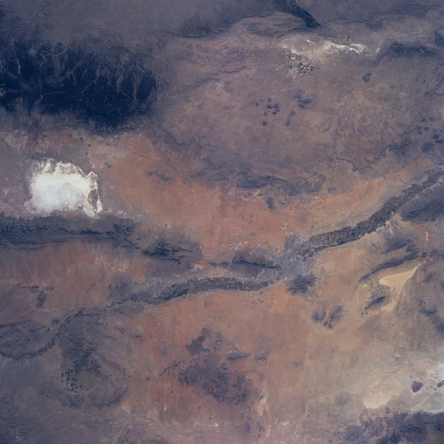 |
| NM23-761-677 Rio Grande Valley, Texas and New Mexico, USA Winter-Spring 1997 Many major natural features, as well as a few human modified landscapes are observed in this synoptic view that shows extreme west Texas, south central New Mexico, and a very small part of Mexico southwest of Ciudad Juarez. The intensively cultivated (irrigated) floodplain of the Rio Grande can be discerned (darker, linear swath) that crosses the picture from northwest to southeast. The Salt Basin of west Texas (small, highly reflective area near the east edge of the image); the much larger and brighter (also highly reflective) White Sands National Monument (the world's largest gypsum dunefield) in south central New Mexico; and the highly reflective salt flats in Mexico (southwest quadrant of the picture) confirms that the entire scene is a desert environment. The San Andres Mountains and the larger, darker Sacramento Mountains (densely forested) border White Sands west and east respectively. The location of El Paso (TX) and Las Cruces (NM) plus El Paso's twin city in Mexico, Ciudad Juarez, can be identified. There is also a small area of irrigated agriculture, mainly center pivot, along the northwest edge of the Salt Basin immediately west of the Guadalupe Mountains (eastern edge of image). |
| Images: | All Available Images Low-Resolution 312k |
|
| Mission: | NM23 |
|
| Roll - Frame: | 761 - 677 |
|
| Geographical Name: | USA-NEW MEXICO |
|
| Features: | WHITE SANDS, EL PASO |
|
| Center Lat x Lon: | 32.5N x 106.5W |
|
| Film Exposure: | N | N=Normal exposure, U=Under exposed, O=Over exposed, F=out of Focus |
| Percentage of Cloud Cover-CLDP: | 0 |
|
| Camera:: | HB |
|
| Camera Tilt: | LO | LO=Low Oblique, HO=High Oblique, NV=Near Vertical |
| Camera Focal Length: | 100 |
|
| Nadir to Photo Center Direction: | E | The direction from the nadir to the center point, N=North, S=South, E=East, W=West |
| Stereo?: | Y | Y=Yes there is an adjacent picture of the same area, N=No there isn't |
| Orbit Number: | 999 |
|
| Date: | 19970503 | YYYYMMDD |
| Time: | 153018 | GMT HHMMSS |
| Nadir Lat: | 34.8N |
Latitude of suborbital point of spacecraft |
| Nadir Lon: | 111.5W |
Longitude of suborbital point of spacecraft |
| Sun Azimuth: | 94 | Clockwise angle in degrees from north to the sun measured at the nadir point |
| Space Craft Altitude: | 207 | nautical miles |
| Sun Elevation: | 35 | Angle in degrees between the horizon and the sun, measured at the nadir point |
| Land Views: | MOUNTAIN, DUNE, DESERT |
|
| Water Views: | RIVER, PLAYA |
|
| Atmosphere Views: | |
|
| Man Made Views: | |
|
| City Views: | |
|
Photo is not associated with any sequences | ||
| NASA Home Page |
JSC Home Page |
JSC Digital Image Collection |
Earth Science & Remote Sensing |
|
This service is provided by the International Space Station program and the JSC Earth Science & Remote Sensing Unit, ARES Division, Exploration Integration Science Directorate.

|