Geographic Region: UK-WALES
Feature: CAMBRIAN MOUNTAINS, COAST, LIVERPOOL
|
Geographic Region: UK-WALES Feature: CAMBRIAN MOUNTAINS, COAST, LIVERPOOL |
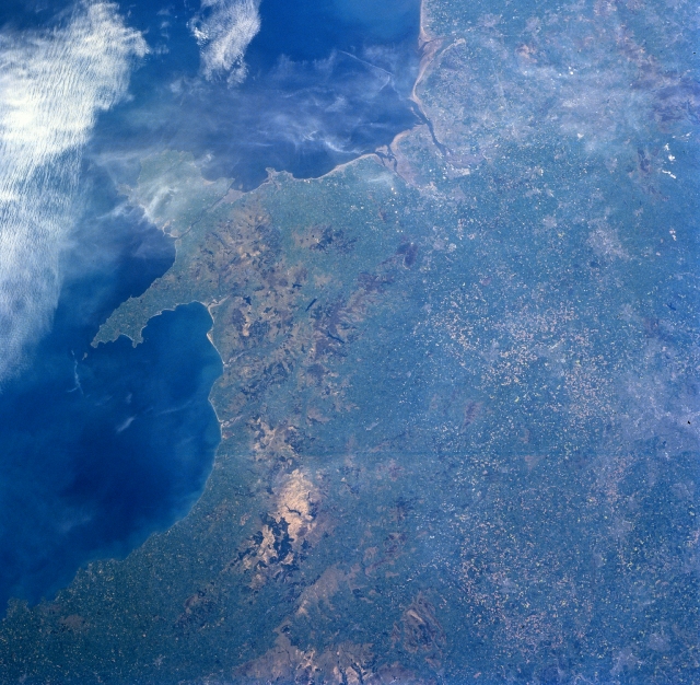 |
| NM23-758-650 Cambrian Mountains, Great Britain Winter/Spring 1997 An agricultural region and Cambrian Mountains of west-central Great Britain can be seen in this north-looking view. The agricultural lands visible on the right center and bottom right portion of the image are part of the Severn River Basin, the largest river basin in Great Britain. To the west of the agricultural Severn River Basin are the rugged Cambrian Mountains, an upland plateau cut by deep river valleys. West (left) of the Cambrian Mountains are the waters of the Saint Georges Channel, which links the Irish Sea (north--upper left)) with the Atlantic Ocean to the south (not visible on image). Midway between the top center and the center of the image, is the industrial and major port city of Liverpool. The city is one of Great Britain's largest cities and is the major outlet for industrial exports. Liverpool is located on the Irish Sea Coast near the mouth of the Mersey River. |
| Images: | All Available Images Low-Resolution 366k |
|
| Mission: | NM23 |
|
| Roll - Frame: | 758 - 650 |
|
| Geographical Name: | UK-WALES |
|
| Features: | CAMBRIAN MOUNTAINS, COAST, LIVERPOOL |
|
| Center Lat x Lon: | 52.5N x 3.5W |
|
| Film Exposure: | N | N=Normal exposure, U=Under exposed, O=Over exposed, F=out of Focus |
| Percentage of Cloud Cover-CLDP: | 25 |
|
| Camera:: | HB |
|
| Camera Tilt: | LO | LO=Low Oblique, HO=High Oblique, NV=Near Vertical |
| Camera Focal Length: | 100 |
|
| Nadir to Photo Center Direction: | The direction from the nadir to the center point, N=North, S=South, E=East, W=West |
|
| Stereo?: | Y | Y=Yes there is an adjacent picture of the same area, N=No there isn't |
| Orbit Number: | |
|
| Date: | 19970503 | YYYYMMDD |
| Time: | GMT HHMMSS |
|
| Nadir Lat: | N |
Latitude of suborbital point of spacecraft |
| Nadir Lon: | E |
Longitude of suborbital point of spacecraft |
| Sun Azimuth: | Clockwise angle in degrees from north to the sun measured at the nadir point |
|
| Space Craft Altitude: | nautical miles |
|
| Sun Elevation: | Angle in degrees between the horizon and the sun, measured at the nadir point |
|
| Land Views: | MOUNTAIN, COAST, PLAIN |
|
| Water Views: | |
|
| Atmosphere Views: | |
|
| Man Made Views: | AGRICULTURE, URBAN AREA |
|
| City Views: | |
|
Photo is not associated with any sequences | ||
| NASA Home Page |
JSC Home Page |
JSC Digital Image Collection |
Earth Science & Remote Sensing |
|
This service is provided by the International Space Station program and the JSC Earth Science & Remote Sensing Unit, ARES Division, Exploration Integration Science Directorate.

|