Geographic Region: UK-WALES
Feature: BRISTOL CHANNEL, CARDIGAN BAY
|
Geographic Region: UK-WALES Feature: BRISTOL CHANNEL, CARDIGAN BAY |
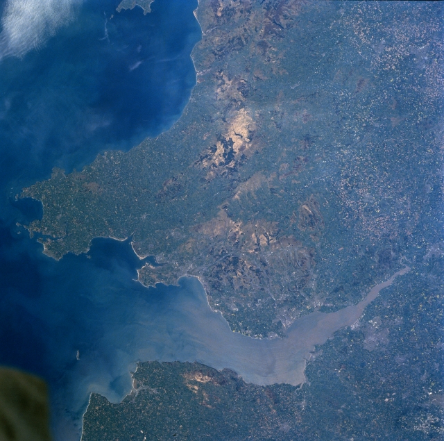 |
| NM23-758-649 Cambrian Mountains, Bristol Channel, Great Britain Winter/Spring 1997 The Cambrian Mountains can be seen extending from the north (top center of the image) southward to the Bristol Channel in this north-looking view. A rugged upland plateau, the Cambrian Mountains cover most of central Wales. The region has deep small lakes and is cut by numerous river valleys. Slightly below the center of the image, a section of the southern Cambrian Mountains known as the Brecon Beacons are visible. The Brecon Beacons are two sandstone peaks that reach an altitude in excess of 2900 feet (885 meters). The Bristol Channel, an arm of the Atlantic Ocean, can be seen extending from near the right edge of the image (east) to the lower left portion of the image (west). The channel is 85 miles (135 km) long and from 5 to 50 miles (8 to 81 km) wide and separates Wales (north) from southwest England (south or bottom portion of the image). The Bristol Channel serves as a major shipping corridor for southwest Great Britain. A portion of Cardigan Bay is visible in the upper left portion of the image. |
| Images: | All Available Images Low-Resolution 353k |
|
| Mission: | NM23 |
|
| Roll - Frame: | 758 - 649 |
|
| Geographical Name: | UK-WALES |
|
| Features: | BRISTOL CHANNEL, CARDIGAN BAY |
|
| Center Lat x Lon: | 52.0N x 3.5W |
|
| Film Exposure: | N | N=Normal exposure, U=Under exposed, O=Over exposed, F=out of Focus |
| Percentage of Cloud Cover-CLDP: | 0 |
|
| Camera:: | HB |
|
| Camera Tilt: | LO | LO=Low Oblique, HO=High Oblique, NV=Near Vertical |
| Camera Focal Length: | 100 |
|
| Nadir to Photo Center Direction: | The direction from the nadir to the center point, N=North, S=South, E=East, W=West |
|
| Stereo?: | Y | Y=Yes there is an adjacent picture of the same area, N=No there isn't |
| Orbit Number: | |
|
| Date: | 19970503 | YYYYMMDD |
| Time: | GMT HHMMSS |
|
| Nadir Lat: | N |
Latitude of suborbital point of spacecraft |
| Nadir Lon: | E |
Longitude of suborbital point of spacecraft |
| Sun Azimuth: | Clockwise angle in degrees from north to the sun measured at the nadir point |
|
| Space Craft Altitude: | nautical miles |
|
| Sun Elevation: | Angle in degrees between the horizon and the sun, measured at the nadir point |
|
| Land Views: | MOUNTAIN, COAST, PLAIN |
|
| Water Views: | CHANNEL |
|
| Atmosphere Views: | |
|
| Man Made Views: | AGRICULTURE |
|
| City Views: | |
|
Photo is not associated with any sequences | ||
| NASA Home Page |
JSC Home Page |
JSC Digital Image Collection |
Earth Science & Remote Sensing |
|
This service is provided by the International Space Station program and the JSC Earth Science & Remote Sensing Unit, ARES Division, Exploration Integration Science Directorate.

|