
Geographic Region: SPAIN
Feature: PYRENEES MOUNTAINS
|
Geographic Region: SPAIN Feature: PYRENEES MOUNTAINS |
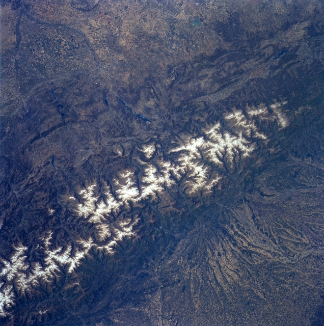 |
| NM23-757-043 Pyrenees Mountains, France and Spain Winter/Spring 1997 The east to west trending snow capped Pyrenees Mountains form a natural border between France (north-bottom) and Spain (south-top). The landscape of the landforms on either side of the mountains is dramatically different. Large, alluvial fans can be seen radiating northward providing rich soils for a thriving agricultural economy on the French side of the mountains. While south of the mountains in Spain, the landscape is more rugged with numerous escarpments and steep cliffs that parallel the main axis of the Pyrenees. Within the higher elevations of the Pyrenees, numerous, deep glacially formed U-shaped valleys are arrayed in no set pattern. The picturesque but rugged terrain of the Pyrenees Mountains offer a natural environment for a variety of tourist attractions that includes hiking trails, sightseeing venues, health spas, winter and summer sports, as well as fine cuisine. The Principality of Andorra, a small mountainous country with only 187 square miles (486 square km) of territory and an estimated population of 63000 permanent residents, can be located towards the lower left corner of the image. |
| Images: | All Available Images Low-Resolution 387k |
|
| Mission: | NM23 |
|
| Roll - Frame: | 757 - 43 |
|
| Geographical Name: | SPAIN |
|
| Features: | PYRENEES MOUNTAINS |
|
| Center Lat x Lon: | 42.0N x .0E |
|
| Film Exposure: | N | N=Normal exposure, U=Under exposed, O=Over exposed, F=out of Focus |
| Percentage of Cloud Cover-CLDP: | 0 |
|
| Camera:: | HB |
|
| Camera Tilt: | LO | LO=Low Oblique, HO=High Oblique, NV=Near Vertical |
| Camera Focal Length: | 100 |
|
| Nadir to Photo Center Direction: | W | The direction from the nadir to the center point, N=North, S=South, E=East, W=West |
| Stereo?: | Y | Y=Yes there is an adjacent picture of the same area, N=No there isn't |
| Orbit Number: | 999 |
|
| Date: | 19970501 | YYYYMMDD |
| Time: | 094422 | GMT HHMMSS |
| Nadir Lat: | 44.3N |
Latitude of suborbital point of spacecraft |
| Nadir Lon: | 5.4E |
Longitude of suborbital point of spacecraft |
| Sun Azimuth: | 132 | Clockwise angle in degrees from north to the sun measured at the nadir point |
| Space Craft Altitude: | 208 | nautical miles |
| Sun Elevation: | 53 | Angle in degrees between the horizon and the sun, measured at the nadir point |
| Land Views: | MOUNTAIN, VALLEY |
|
| Water Views: | RIVER |
|
| Atmosphere Views: | |
|
| Man Made Views: | |
|
| City Views: | |
|
Photo is not associated with any sequences | ||
| NASA Home Page |
JSC Home Page |
JSC Digital Image Collection |
Earth Science & Remote Sensing |
|
This service is provided by the International Space Station program and the JSC Earth Science & Remote Sensing Unit, ARES Division, Exploration Integration Science Directorate.

|