
Geographic Region: USA-ARIZONA
Feature: BALDY PEAK
|
Geographic Region: USA-ARIZONA Feature: BALDY PEAK |
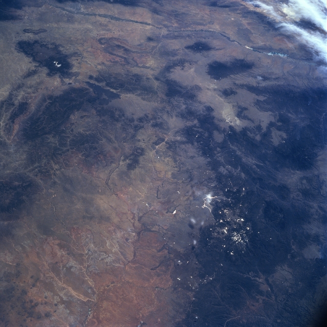 |
| NM23-756-397 Little Colorado River Basin, Arizona, USA Winter-Spring 1997 The lighter colored terrain, with numerous intermittent tributaries feeding into a central stream channel (foreground), is the Little Colorado River Basin. While most of the basin lies in Arizona, some of the tributaries originate in west central New Mexico (center of the image). The darker features that are scattered throughout the picture are mountains and plateaus. The Zuni Mountains can be identified along the northwest side of the basin and a sizable lava valley (dark, uniform area) is even visible southeast of the Zuni Mountains. A number of mountain ranges, including partially snow-capped Baldy Peak (11,403 feet--3476 meters) that is located within the Apache-Sitgreaves National Forest in east-central Arizona, can also be observed along the southern edge of the picture. Although a highway is not discernible on this small-scale image, Interstate Highway 40 skirts along the northern edge of the image. The north-south trending Rio Grande Valley (thin, darker, linear feature) is discernible along the entire top (east side) of the picture. Albuquerque (barely discernible) lies between the Rio Grande and the Sandia Mountains (partly under clouds, top right corner). |
| Images: | All Available Images Low-Resolution 318k |
|
| Mission: | NM23 |
|
| Roll - Frame: | 756 - 397 |
|
| Geographical Name: | USA-ARIZONA |
|
| Features: | BALDY PEAK |
|
| Center Lat x Lon: | 34.5N x 109.5W |
|
| Film Exposure: | N | N=Normal exposure, U=Under exposed, O=Over exposed, F=out of Focus |
| Percentage of Cloud Cover-CLDP: | 5 |
|
| Camera:: | HB |
|
| Camera Tilt: | 41 | LO=Low Oblique, HO=High Oblique, NV=Near Vertical |
| Camera Focal Length: | 100 |
|
| Nadir to Photo Center Direction: | S | The direction from the nadir to the center point, N=North, S=South, E=East, W=West |
| Stereo?: | Y | Y=Yes there is an adjacent picture of the same area, N=No there isn't |
| Orbit Number: | 999 |
|
| Date: | 19970430 | YYYYMMDD |
| Time: | 164608 | GMT HHMMSS |
| Nadir Lat: | 37.4N |
Latitude of suborbital point of spacecraft |
| Nadir Lon: | 108.8W |
Longitude of suborbital point of spacecraft |
| Sun Azimuth: | 115 | Clockwise angle in degrees from north to the sun measured at the nadir point |
| Space Craft Altitude: | 208 | nautical miles |
| Sun Elevation: | 51 | Angle in degrees between the horizon and the sun, measured at the nadir point |
| Land Views: | BASIN, MOUNTAIN |
|
| Water Views: | RIVER |
|
| Atmosphere Views: | |
|
| Man Made Views: | |
|
| City Views: | |
|
Photo is not associated with any sequences | ||
| NASA Home Page |
JSC Home Page |
JSC Digital Image Collection |
Earth Science & Remote Sensing |
|
This service is provided by the International Space Station program and the JSC Earth Science & Remote Sensing Unit, ARES Division, Exploration Integration Science Directorate.

|