Geographic Region: MONGOLIA
Feature: UVS LAKE
|
Geographic Region: MONGOLIA Feature: UVS LAKE |
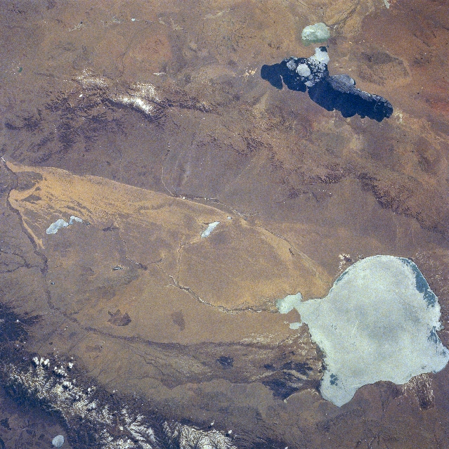 |
| NM23-751-366 Uvs and Hyargas Lakes, Mongolia Winter/Spring 1997 Located in the lower right portion of the image, the ice-covered Uvs Lake, the largest salt lake in Mongolia, can be seen in this southeast-looking view. Covering an area of 1300 sq. miles (3370 sq. km), Uvs Lake has an average depth of only 20 feet (6 meters) with a maximum depth reaching 33 feet (10 meters). Situated in a basin, the lake is now part of a protected area by the International Geosphere-Biosphere Program for global change research. The range of ecological zones in this relatively small area of the Uvs Lake Basin is matched by few places in the world according to scientist working in the program. To the east (left) of the lake are the dunes of the Altan Els or "Golden Sands". Uvs Lake is fringed by marshes. The Turgen Mountains, with small glaciers and permanent snow, are visible to the north of the lake (bottom left of the image). The Tsagaan Shuvuut Range is discernible to the south of the Altan Els (upper left of the image). The partially ice-covered Hyargas or Khirgiz Lake can be seen in the upper right portion of the image. |
| Images: | All Available Images Low-Resolution 404k |
|
| Mission: | NM23 |
|
| Roll - Frame: | 751 - 366 |
|
| Geographical Name: | MONGOLIA |
|
| Features: | UVS LAKE |
|
| Center Lat x Lon: | 50.0N x 93.5E |
|
| Film Exposure: | N | N=Normal exposure, U=Under exposed, O=Over exposed, F=out of Focus |
| Percentage of Cloud Cover-CLDP: | 5 |
|
| Camera:: | HB |
|
| Camera Tilt: | 26 | LO=Low Oblique, HO=High Oblique, NV=Near Vertical |
| Camera Focal Length: | 100 |
|
| Nadir to Photo Center Direction: | S | The direction from the nadir to the center point, N=North, S=South, E=East, W=West |
| Stereo?: | Y | Y=Yes there is an adjacent picture of the same area, N=No there isn't |
| Orbit Number: | 999 |
|
| Date: | 19970429 | YYYYMMDD |
| Time: | 070509 | GMT HHMMSS |
| Nadir Lat: | 51.7N |
Latitude of suborbital point of spacecraft |
| Nadir Lon: | 93.2E |
Longitude of suborbital point of spacecraft |
| Sun Azimuth: | 211 | Clockwise angle in degrees from north to the sun measured at the nadir point |
| Space Craft Altitude: | 209 | nautical miles |
| Sun Elevation: | 50 | Angle in degrees between the horizon and the sun, measured at the nadir point |
| Land Views: | DESERT, MOUNTAIN, BASIN |
|
| Water Views: | LAKE, ICE |
|
| Atmosphere Views: | |
|
| Man Made Views: | |
|
| City Views: | |
|
Photo is not associated with any sequences | ||
| NASA Home Page |
JSC Home Page |
JSC Digital Image Collection |
Earth Science & Remote Sensing |
|
This service is provided by the International Space Station program and the JSC Earth Science & Remote Sensing Unit, ARES Division, Exploration Integration Science Directorate.

|