Geographic Region: KAZAKHSTAN
Feature: ZHIDELI RIVER DELTA
|
Geographic Region: KAZAKHSTAN Feature: ZHIDELI RIVER DELTA |
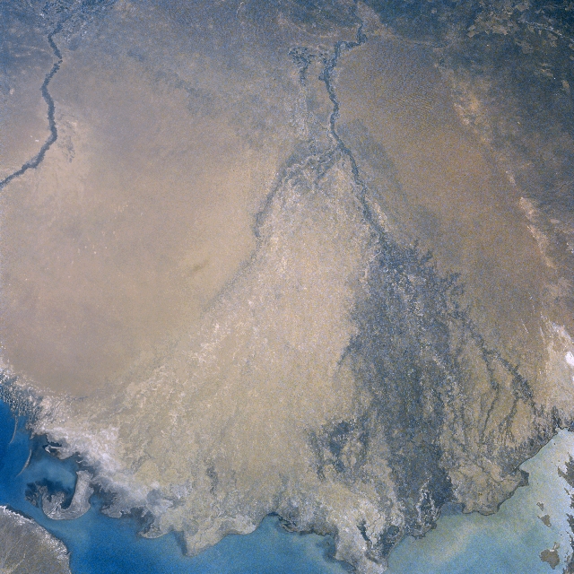 |
| NM23-751-353 Ili River Delta, Kazakhstan Winter-Spring 1997 The waters of the Ili River emptying into Lake Balkhash (lower portion of image) can be seen in this south-southeast-looking view. Rising in the northern ranges of the Tien Shan, the Ili River is nearly 590 miles long (950 km). The river flows through the sandy Sarysesik-Atyran Desert (discernible on image) on its way to Lake Balkhash. During the rainy season, the river is navigable from the small city of Ili for about 280 miles (451 km). Toward the river's mouth, the area surrounding the Ili River is swampy. Irrigation is prevalent along its banks upstream from the river's mouth. A portion of the Karatal River is visible in the upper left portion of the image. |
| Images: | All Available Images Low-Resolution 376k |
|
| Mission: | NM23 |
|
| Roll - Frame: | 751 - 353 |
|
| Geographical Name: | KAZAKHSTAN |
|
| Features: | ZHIDELI RIVER DELTA |
|
| Center Lat x Lon: | 45.5N x 75.5E |
|
| Film Exposure: | N | N=Normal exposure, U=Under exposed, O=Over exposed, F=out of Focus |
| Percentage of Cloud Cover-CLDP: | 0 |
|
| Camera:: | HB |
|
| Camera Tilt: | 50 | LO=Low Oblique, HO=High Oblique, NV=Near Vertical |
| Camera Focal Length: | 100 |
|
| Nadir to Photo Center Direction: | SE | The direction from the nadir to the center point, N=North, S=South, E=East, W=West |
| Stereo?: | Y | Y=Yes there is an adjacent picture of the same area, N=No there isn't |
| Orbit Number: | 999 |
|
| Date: | 19970429 | YYYYMMDD |
| Time: | 070138 | GMT HHMMSS |
| Nadir Lat: | 48.9N |
Latitude of suborbital point of spacecraft |
| Nadir Lon: | 73.1E |
Longitude of suborbital point of spacecraft |
| Sun Azimuth: | 178 | Clockwise angle in degrees from north to the sun measured at the nadir point |
| Space Craft Altitude: | 209 | nautical miles |
| Sun Elevation: | 56 | Angle in degrees between the horizon and the sun, measured at the nadir point |
| Land Views: | DESERT |
|
| Water Views: | RIVER, DELTA, SWAMP |
|
| Atmosphere Views: | |
|
| Man Made Views: | AGRICULTURE |
|
| City Views: | |
|
Photo is not associated with any sequences | ||
| NASA Home Page |
JSC Home Page |
JSC Digital Image Collection |
Earth Science & Remote Sensing |
|
This service is provided by the International Space Station program and the JSC Earth Science & Remote Sensing Unit, ARES Division, Exploration Integration Science Directorate.

|