
Geographic Region: USA-MASSACHUSETTS
Feature: MARTHAS VINEYARD, C. COD
|
Geographic Region: USA-MASSACHUSETTS Feature: MARTHAS VINEYARD, C. COD |
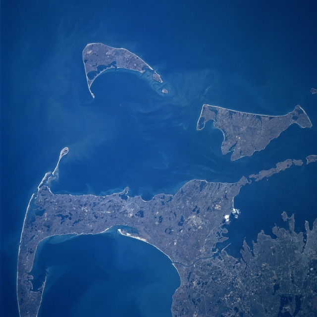 |
| NM23-744-635 Cape Cod, Nantucket and Marthas Vineyard Islands, Massachusetts Spring 1997 Looking generally to the south, Cape Cod and the islands of Nantucket and Marthas Vineyard are visible in this synoptic view. Nantucket Island is located 30 miles (48 km) off the coast of southeast Massachusetts. The island is 14 miles (23 km) long and from 3 to 6 miles (5 to 10 km) wide. Nantucket Island has many sandy beaches and low rolling hills composed of sand and gravel. Marthas Vineyard is the larger of the two islands and is triangular shaped island situated 7 miles (11 km) off the southern coast of Massachusetts. Marthas Vineyard is 23 miles (37 km) wide (east to west) and 9 miles (14 km) long (north to south), and covers 100 sq. miles (259 sq. km). Both islands are favorite tourist and resort areas. North of Martha's Vineyard (right center), the Elizabeth Islands and Buzzards Bay are visible. Cape Cod Bay is in the lower left portion of the image. |
| Images: | All Available Images Low-Resolution 286k |
|
| Mission: | NM23 |
|
| Roll - Frame: | 744 - 635 |
|
| Geographical Name: | USA-MASSACHUSETTS |
|
| Features: | MARTHAS VINEYARD, C. COD |
|
| Center Lat x Lon: | 41.5N x 70.5W |
|
| Film Exposure: | N | N=Normal exposure, U=Under exposed, O=Over exposed, F=out of Focus |
| Percentage of Cloud Cover-CLDP: | 5 |
|
| Camera:: | HB |
|
| Camera Tilt: | 47 | LO=Low Oblique, HO=High Oblique, NV=Near Vertical |
| Camera Focal Length: | 250 |
|
| Nadir to Photo Center Direction: | SW | The direction from the nadir to the center point, N=North, S=South, E=East, W=West |
| Stereo?: | Y | Y=Yes there is an adjacent picture of the same area, N=No there isn't |
| Orbit Number: | 999 |
|
| Date: | 19970422 | YYYYMMDD |
| Time: | 180509 | GMT HHMMSS |
| Nadir Lat: | 44.2N |
Latitude of suborbital point of spacecraft |
| Nadir Lon: | 67.9W |
Longitude of suborbital point of spacecraft |
| Sun Azimuth: | 220 | Clockwise angle in degrees from north to the sun measured at the nadir point |
| Space Craft Altitude: | 210 | nautical miles |
| Sun Elevation: | 52 | Angle in degrees between the horizon and the sun, measured at the nadir point |
| Land Views: | ISLAND, COAST, DUNE |
|
| Water Views: | BAY, CHANNEL |
|
| Atmosphere Views: | |
|
| Man Made Views: | |
|
| City Views: | |
|
Photo is not associated with any sequences | ||
| NASA Home Page |
JSC Home Page |
JSC Digital Image Collection |
Earth Science & Remote Sensing |
|
This service is provided by the International Space Station program and the JSC Earth Science & Remote Sensing Unit, ARES Division, Exploration Integration Science Directorate.

|