
Geographic Region: USA-MASSACHUSETTS
Feature: CAPE COD
|
Geographic Region: USA-MASSACHUSETTS Feature: CAPE COD |
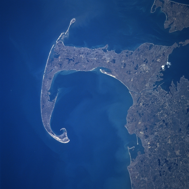 |
| NM23-744-633 Cape Cod, Massachusetts Spring, 1997 Cape Cod and Cape Cod Bay (visible at the center of the image) can be seen in this generally south-looking view. Cape Cod is a narrow peninsula, glacial in origin that is constantly changing as winds and water move sand along the shoreline. Cape Cod extends 65 miles (105 km) east and north into the Atlantic Ocean. Parts of Cape Cod peninsula constitute the Cape Cod National Seashore, an area covering 44600 acres (18063 hectares). This area contains beaches, sand dunes, marshes, freshwater ponds, and historic sites, including the first Marconi wireless station in the United States. A portion of Martha's Vineyard can be seen in the upper right corner of the image. |
| Images: | All Available Images Low-Resolution 279k |
|
| Mission: | NM23 |
|
| Roll - Frame: | 744 - 633 |
|
| Geographical Name: | USA-MASSACHUSETTS |
|
| Features: | CAPE COD |
|
| Center Lat x Lon: | 42.0N x 70.5W |
|
| Film Exposure: | N | N=Normal exposure, U=Under exposed, O=Over exposed, F=out of Focus |
| Percentage of Cloud Cover-CLDP: | 0 |
|
| Camera:: | HB |
|
| Camera Tilt: | 40 | LO=Low Oblique, HO=High Oblique, NV=Near Vertical |
| Camera Focal Length: | 250 |
|
| Nadir to Photo Center Direction: | SW | The direction from the nadir to the center point, N=North, S=South, E=East, W=West |
| Stereo?: | Y | Y=Yes there is an adjacent picture of the same area, N=No there isn't |
| Orbit Number: | 999 |
|
| Date: | 19970422 | YYYYMMDD |
| Time: | 180504 | GMT HHMMSS |
| Nadir Lat: | 44.0N |
Latitude of suborbital point of spacecraft |
| Nadir Lon: | 68.3W |
Longitude of suborbital point of spacecraft |
| Sun Azimuth: | 220 | Clockwise angle in degrees from north to the sun measured at the nadir point |
| Space Craft Altitude: | 210 | nautical miles |
| Sun Elevation: | 53 | Angle in degrees between the horizon and the sun, measured at the nadir point |
| Land Views: | COAST, DUNE, CAPE, FOREST |
|
| Water Views: | OCEAN, BAY |
|
| Atmosphere Views: | |
|
| Man Made Views: | |
|
| City Views: | |
|
Photo is not associated with any sequences | ||
| NASA Home Page |
JSC Home Page |
JSC Digital Image Collection |
Earth Science & Remote Sensing |
|
This service is provided by the International Space Station program and the JSC Earth Science & Remote Sensing Unit, ARES Division, Exploration Integration Science Directorate.

|