
Geographic Region: ITALY
Feature: LAKE MAGGIORE, ALPS
|
Geographic Region: ITALY Feature: LAKE MAGGIORE, ALPS |
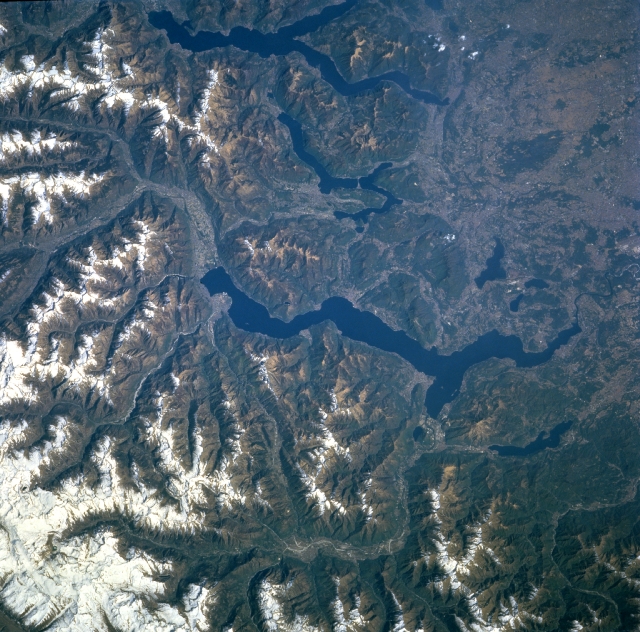 |
| NM23-743-051 Glacial Lakes, Italy Winter/Spring 1997 Glaciated, U-shaped river valleys are visible as they provide melt-water runoff that flows into the elongated lakes (dark features) in northwest Italy. From east to west (top to center) the three larger lakes are Lake Como, Lake Lugano (smallest of the three), and Lake Maggiore (largest-center of image). Several smaller lakes (also dark features) can be identified east and west of the southern end of Lake Maggiore. Sufficient water flows through the Alpine valleys around the Po River Basin to place Italy among the leading nations of Europe in terms of generating hydroelectricity. The lakes are constantly re-charged by melting valley glaciers and snow from the Swiss and Italian Alps. While most of the scene covers northwest Italy, a small piece of Switzerland is visible, particularly in the northeast quadrant (upper left) of the image. The Ticimo River (winding valley feature--bottom of image), a tributary of the Po River, can be traced as it crosses a variety of landforms that includes the Swiss and Italian Alps, Lake Maggiore, and finally becomes part of the Padana Plain (middle, right edge of scene). |
| Images: | All Available Images Low-Resolution 384k |
|
| Mission: | NM23 |
|
| Roll - Frame: | 743 - 51 |
|
| Geographical Name: | ITALY |
|
| Features: | LAKE MAGGIORE, ALPS |
|
| Center Lat x Lon: | 46.0N x 8.5E |
|
| Film Exposure: | N | N=Normal exposure, U=Under exposed, O=Over exposed, F=out of Focus |
| Percentage of Cloud Cover-CLDP: | 0 |
|
| Camera:: | HB |
|
| Camera Tilt: | LO | LO=Low Oblique, HO=High Oblique, NV=Near Vertical |
| Camera Focal Length: | 250 |
|
| Nadir to Photo Center Direction: | NE | The direction from the nadir to the center point, N=North, S=South, E=East, W=West |
| Stereo?: | Y | Y=Yes there is an adjacent picture of the same area, N=No there isn't |
| Orbit Number: | 999 |
|
| Date: | 19970424 | YYYYMMDD |
| Time: | 111705 | GMT HHMMSS |
| Nadir Lat: | 12.2S |
Latitude of suborbital point of spacecraft |
| Nadir Lon: | 35.9W |
Longitude of suborbital point of spacecraft |
| Sun Azimuth: | 63 | Clockwise angle in degrees from north to the sun measured at the nadir point |
| Space Craft Altitude: | 209 | nautical miles |
| Sun Elevation: | 38 | Angle in degrees between the horizon and the sun, measured at the nadir point |
| Land Views: | MOUNTAIN, VALLEY |
|
| Water Views: | LAKE, RIVER |
|
| Atmosphere Views: | |
|
| Man Made Views: | |
|
| City Views: | |
|
Photo is not associated with any sequences | ||
| NASA Home Page |
JSC Home Page |
JSC Digital Image Collection |
Earth Science & Remote Sensing |
|
This service is provided by the International Space Station program and the JSC Earth Science & Remote Sensing Unit, ARES Division, Exploration Integration Science Directorate.

|