
Geographic Region: SWITZERLAND
Feature: LAKE GENEVA, JURA MTS.
|
Geographic Region: SWITZERLAND Feature: LAKE GENEVA, JURA MTS. |
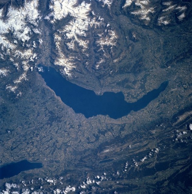 |
| NM23-743-047 Lake Geneva, Switzerland Winter/Spring 1997 The crescent-shaped Lake Geneva can be seen in this southeast-looking view. Surrounded by the Alps to the south and east (upper portion of the image), and the Jura Mountains to the west (lower portion of the image), Lake Geneva is 45 miles (70 km) long and 1.5 to 9 miles (1 to 14 km) wide. The lake covers an area of 224 square miles (580 square km). The maximum depth of Lake Geneva is 1,017 feet (310 meters). The Rhone River traverses the lake from east to west, emerging at the western end at the city of Geneva. Lake Geneva is noted for its deep blue and remarkably transparent waters and the shores of the lake are dotted with numerous resorts and villas. The slopes of the northern shore of the lake (left) are dotted with many vineyards and orchards. Lake Geneva is subject to seiches (tidal fluctuations) that suddenly change the lake's level. Near the bottom left of the image, the southwestern portion of the Lake of Neuchatal is visible. The lake is 24 miles (39 km) long and 4 to 5 miles (6 to 8 km) wide. The city of Geneva is located at the western end of the Lake Geneva. Geneva is the seat of many international bodies, such as the Red Cross, the World Health Organization, the International Labor Organization, and the World Meteorological Organization. |
| Images: | All Available Images Low-Resolution 388k |
|
| Mission: | NM23 |
|
| Roll - Frame: | 743 - 47 |
|
| Geographical Name: | SWITZERLAND |
|
| Features: | LAKE GENEVA, JURA MTS. |
|
| Center Lat x Lon: | 46.5N x 6.5E |
|
| Film Exposure: | N | N=Normal exposure, U=Under exposed, O=Over exposed, F=out of Focus |
| Percentage of Cloud Cover-CLDP: | 5 |
|
| Camera:: | HB |
|
| Camera Tilt: | LO | LO=Low Oblique, HO=High Oblique, NV=Near Vertical |
| Camera Focal Length: | 250 |
|
| Nadir to Photo Center Direction: | NE | The direction from the nadir to the center point, N=North, S=South, E=East, W=West |
| Stereo?: | Y | Y=Yes there is an adjacent picture of the same area, N=No there isn't |
| Orbit Number: | 999 |
|
| Date: | 19970424 | YYYYMMDD |
| Time: | 111645 | GMT HHMMSS |
| Nadir Lat: | 13.2S |
Latitude of suborbital point of spacecraft |
| Nadir Lon: | 36.6W |
Longitude of suborbital point of spacecraft |
| Sun Azimuth: | 63 | Clockwise angle in degrees from north to the sun measured at the nadir point |
| Space Craft Altitude: | 209 | nautical miles |
| Sun Elevation: | 37 | Angle in degrees between the horizon and the sun, measured at the nadir point |
| Land Views: | MOUNTAIN, VALLEY, FAULT |
|
| Water Views: | LAKE |
|
| Atmosphere Views: | |
|
| Man Made Views: | AGRICULTURE |
|
| City Views: | |
|
Photo is not associated with any sequences | ||
| NASA Home Page |
JSC Home Page |
JSC Digital Image Collection |
Earth Science & Remote Sensing |
|
This service is provided by the International Space Station program and the JSC Earth Science & Remote Sensing Unit, ARES Division, Exploration Integration Science Directorate.

|