
Geographic Region: FRANCE
Feature: MARSEILLE, BERRE LAKE
|
Geographic Region: FRANCE Feature: MARSEILLE, BERRE LAKE |
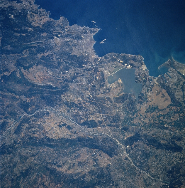 |
| NM23-743-043 Marsielles, France Winter/Spring 1997 Midway between the upper center and center of the image, the port city of Marsielles is discernible in this south-looking view. Located on the Gulf of Lyons (upper right), an arm of the Mediterranean Sea, Marsielles is the second largest city in France and a very important commercial seaport. It is also the oldest city in France. Marsielles is a major industrial city and the site of an army and naval base. An underground canal connects the city with the Rhone River Valley to the northwest. Just below the left center of the image, the Durance River enters the scene. The river traverses the image generally east to west exiting the scene in the bottom right just before emptying into the Rhone River. The Berre Lagoon is visible just to the right of the center of the image. One of the runways of the Marsielles Marignane Airport is discernible extending out into the lagoon. The mouth of the Rhone River is visible at the right center of the image. |
| Images: | All Available Images Low-Resolution 389k |
|
| Mission: | NM23 |
|
| Roll - Frame: | 743 - 43 |
|
| Geographical Name: | FRANCE |
|
| Features: | MARSEILLE, BERRE LAKE |
|
| Center Lat x Lon: | 43.5N x 5.5E |
|
| Film Exposure: | N | N=Normal exposure, U=Under exposed, O=Over exposed, F=out of Focus |
| Percentage of Cloud Cover-CLDP: | 0 |
|
| Camera:: | HB |
|
| Camera Tilt: | LO | LO=Low Oblique, HO=High Oblique, NV=Near Vertical |
| Camera Focal Length: | 250 |
|
| Nadir to Photo Center Direction: | NE | The direction from the nadir to the center point, N=North, S=South, E=East, W=West |
| Stereo?: | Y | Y=Yes there is an adjacent picture of the same area, N=No there isn't |
| Orbit Number: | 999 |
|
| Date: | 19970424 | YYYYMMDD |
| Time: | 111628 | GMT HHMMSS |
| Nadir Lat: | 14S |
Latitude of suborbital point of spacecraft |
| Nadir Lon: | 37.3W |
Longitude of suborbital point of spacecraft |
| Sun Azimuth: | 62 | Clockwise angle in degrees from north to the sun measured at the nadir point |
| Space Craft Altitude: | 209 | nautical miles |
| Sun Elevation: | 36 | Angle in degrees between the horizon and the sun, measured at the nadir point |
| Land Views: | MOUNTAIN, COAST, FAULT |
|
| Water Views: | RIVER, LAGOON |
|
| Atmosphere Views: | |
|
| Man Made Views: | URBAN AREA |
|
| City Views: | |
|
Photo is not associated with any sequences | ||
| NASA Home Page |
JSC Home Page |
JSC Digital Image Collection |
Earth Science & Remote Sensing |
|
This service is provided by the International Space Station program and the JSC Earth Science & Remote Sensing Unit, ARES Division, Exploration Integration Science Directorate.

|