
Geographic Region: FRANCE
Feature: PYRENEES
|
Geographic Region: FRANCE Feature: PYRENEES |
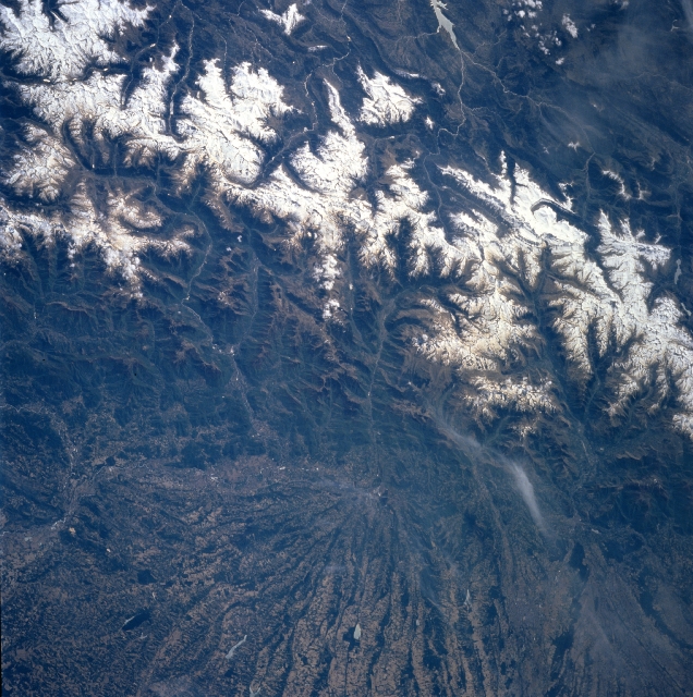 |
| NM23-743-036 Pyrenees Mountains, Spain and France Winter/Spring 1997 The snow-capped Pyrenees Mountains form a natural barrier and border that separates France (bottom-north) and Spain (top-south). Aneto Peak, visible in this image slightly above the center of the picture, is the highest peak (11165 feet-3403 meters) of the Pyrenees. Numerous well-entrenched valleys can be identified on both sides of the border. Although the higher (in elevation) valleys were glaciated during the last ice age (Pleistocene period) and show U-shaped valleys below the jagged peaks, the valleys are not too extensive; and settlement is sparse throughout the mountainous region. An extremely large alluvial fan, marked by alternating dark lines and lighter-colored swaths, is visible radiating northward in France (bottom center). Many source areas (headwaters) of tributary streams are visible (light colored, winding, linear features) in northern Spain as they drain southward to eventually flow into the Ebro River. Streams on the French side of the border eventually empty into the Garonne River. |
| Images: | All Available Images Low-Resolution 391k |
|
| Mission: | NM23 |
|
| Roll - Frame: | 743 - 36 |
|
| Geographical Name: | FRANCE |
|
| Features: | PYRENEES |
|
| Center Lat x Lon: | 43.0N x .5E |
|
| Film Exposure: | N | N=Normal exposure, U=Under exposed, O=Over exposed, F=out of Focus |
| Percentage of Cloud Cover-CLDP: | 5 |
|
| Camera:: | HB |
|
| Camera Tilt: | LO | LO=Low Oblique, HO=High Oblique, NV=Near Vertical |
| Camera Focal Length: | 250 |
|
| Nadir to Photo Center Direction: | NE | The direction from the nadir to the center point, N=North, S=South, E=East, W=West |
| Stereo?: | N | Y=Yes there is an adjacent picture of the same area, N=No there isn't |
| Orbit Number: | 999 |
|
| Date: | 19970424 | YYYYMMDD |
| Time: | 111606 | GMT HHMMSS |
| Nadir Lat: | 15.1S |
Latitude of suborbital point of spacecraft |
| Nadir Lon: | 38.2W |
Longitude of suborbital point of spacecraft |
| Sun Azimuth: | 62 | Clockwise angle in degrees from north to the sun measured at the nadir point |
| Space Craft Altitude: | 209 | nautical miles |
| Sun Elevation: | 34 | Angle in degrees between the horizon and the sun, measured at the nadir point |
| Land Views: | MOUNTAIN, ALLUVIAL FAN, VALLEY |
|
| Water Views: | RIVER |
|
| Atmosphere Views: | |
|
| Man Made Views: | |
|
| City Views: | |
|
Photo is not associated with any sequences | ||
| NASA Home Page |
JSC Home Page |
JSC Digital Image Collection |
Earth Science & Remote Sensing |
|
This service is provided by the International Space Station program and the JSC Earth Science & Remote Sensing Unit, ARES Division, Exploration Integration Science Directorate.

|