
Geographic Region: GERMANY
Feature: RHINE RIVER, MANNHEIM
|
Geographic Region: GERMANY Feature: RHINE RIVER, MANNHEIM |
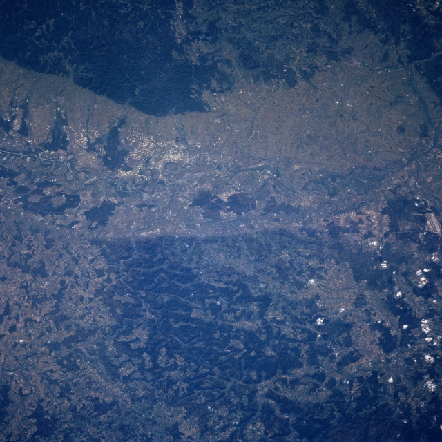 |
| NM23-742-193 Rhine River Valley, Mannheim, Germany Winter/Spring 1997 The Rhine River can be seen entering the scene just above the left center (south) of the view. The river traverses the view and exists the scene at the right center (north) of the view. The Rhine River, 820 miles (1320 km) long is one of the busiest rivers in the world, transporting much of Western Europe's commerce. Along this part of the river, the Rhine flows in a widened valley or trench, formed by the collapse of a segment of the earth's crust. Agriculture is intensive on slopes of the valley. Forested hills (darker landscapes) are visible on both sides of the river valley. The city of Mannheim is located on the east bank of the Rhine River at the confluence of one of the main tributaries of the Rhine, the Neckar River (slightly left of center). The city is a major inland port and an industrial center. |
| Images: | All Available Images Low-Resolution 367k |
|
| Mission: | NM23 |
|
| Roll - Frame: | 742 - 193 |
|
| Geographical Name: | GERMANY |
|
| Features: | RHINE RIVER, MANNHEIM |
|
| Center Lat x Lon: | 49.5N x 8.5E |
|
| Film Exposure: | N | N=Normal exposure, U=Under exposed, O=Over exposed, F=out of Focus |
| Percentage of Cloud Cover-CLDP: | 5 |
|
| Camera:: | HB |
|
| Camera Tilt: | LO | LO=Low Oblique, HO=High Oblique, NV=Near Vertical |
| Camera Focal Length: | 250 |
|
| Nadir to Photo Center Direction: | The direction from the nadir to the center point, N=North, S=South, E=East, W=West |
|
| Stereo?: | Y | Y=Yes there is an adjacent picture of the same area, N=No there isn't |
| Orbit Number: | |
|
| Date: | 19970421 | YYYYMMDD |
| Time: | GMT HHMMSS |
|
| Nadir Lat: | N |
Latitude of suborbital point of spacecraft |
| Nadir Lon: | E |
Longitude of suborbital point of spacecraft |
| Sun Azimuth: | Clockwise angle in degrees from north to the sun measured at the nadir point |
|
| Space Craft Altitude: | nautical miles |
|
| Sun Elevation: | Angle in degrees between the horizon and the sun, measured at the nadir point |
|
| Land Views: | VALLEY, HILL, ESCARPMENT, FOREST |
|
| Water Views: | RIVER |
|
| Atmosphere Views: | |
|
| Man Made Views: | AGRICULTURE, URBAN AREA |
|
| City Views: | |
|
Photo is not associated with any sequences | ||
| NASA Home Page |
JSC Home Page |
JSC Digital Image Collection |
Earth Science & Remote Sensing |
|
This service is provided by the International Space Station program and the JSC Earth Science & Remote Sensing Unit, ARES Division, Exploration Integration Science Directorate.

|