
Geographic Region: BAHAMAS
Feature: TONGUE OF THE OCEAN
|
Geographic Region: BAHAMAS Feature: TONGUE OF THE OCEAN |
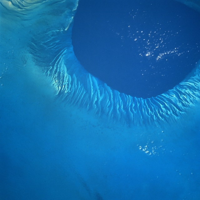 |
| NM23-739-093 Tongue of the Ocean, Bahamas Winter/Spring 1997 The shallow Bahama shelf and the southern portion of the deep Tongue of the Ocean (darker water, upper right) can be seen in this northwest-looking view. The Tongue of the Ocean is one of two main branches that form the Great Bahama Canyon. The vertical rock walls of this submarine canyon rise 14060 feet (4285 meters) from the canyon floor to the surrounding seabed. The Grand Bahama Canyon has been traced for more than 140 miles (225 km) in length. The canyon has a width of 23 miles (37 km) at its deepest point and an average floor slope of about 300 feet per mile (60 meters per km). During the last Ice Age, nearly 12000 years ago, much of the Bahama Shelf was above sea level. Rainfall during that period formed erosional type gullies or small canyons as rainwater flowed off the shelf into the Tongue of the Ocean. As the climate warmed and the ice melted, sea levels rose to present levels covering the eroded gullies seen on this image. |
| Images: | All Available Images Low-Resolution 280k |
|
| Mission: | NM23 |
|
| Roll - Frame: | 739 - 93 |
|
| Geographical Name: | BAHAMAS |
|
| Features: | TONGUE OF THE OCEAN |
|
| Center Lat x Lon: | 23.5N x 77W |
|
| Film Exposure: | N | N=Normal exposure, U=Under exposed, O=Over exposed, F=out of Focus |
| Percentage of Cloud Cover-CLDP: | 5 |
|
| Camera:: | HB |
|
| Camera Tilt: | LO | LO=Low Oblique, HO=High Oblique, NV=Near Vertical |
| Camera Focal Length: | 250 |
|
| Nadir to Photo Center Direction: | W | The direction from the nadir to the center point, N=North, S=South, E=East, W=West |
| Stereo?: | Y | Y=Yes there is an adjacent picture of the same area, N=No there isn't |
| Orbit Number: | 999 |
|
| Date: | 19970418 | YYYYMMDD |
| Time: | 173418 | GMT HHMMSS |
| Nadir Lat: | 19.5N |
Latitude of suborbital point of spacecraft |
| Nadir Lon: | 77.9E |
Longitude of suborbital point of spacecraft |
| Sun Azimuth: | 328 | Clockwise angle in degrees from north to the sun measured at the nadir point |
| Space Craft Altitude: | 211 | nautical miles |
| Sun Elevation: | -55 | Angle in degrees between the horizon and the sun, measured at the nadir point |
| Land Views: | EROSION |
|
| Water Views: | OCEAN |
|
| Atmosphere Views: | |
|
| Man Made Views: | |
|
| City Views: | |
|
Photo is not associated with any sequences | ||
| NASA Home Page |
JSC Home Page |
JSC Digital Image Collection |
Earth Science & Remote Sensing |
|
This service is provided by the International Space Station program and the JSC Earth Science & Remote Sensing Unit, ARES Division, Exploration Integration Science Directorate.

|