Geographic Region: ARGENTINA
Feature: LAKE VIEDMA
|
Geographic Region: ARGENTINA Feature: LAKE VIEDMA |
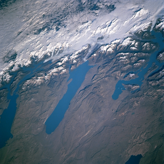 |
| NM23-722-000G Lakes Viedma, San Martin, Argentino, Argentina Winter/Spring 1997 Fed by glaciers from the Andes Mountains, Lakes Argentino (left center of image), Viedma (center of image), and San Martin (right center of image) can be seen in this southwest-looking view. The large glacier is the remnant of a much larger glacier that covered not only the Andes, but portions of western Patagonia over 15000 years ago. As the climate warmed, the glacier began to retreat about 13000 years ago. Meltwater from the glaciers filled the basins forming large lakes, some of which are visible in this image. The lakes continue to be fed by the meltwater of the glaciers and small streams emanating from the glaciers. At an elevation of 1100 feet (336 meters), Lake Viedma's only outlet flows southward into Lake Argentino whose outlet, the Santa Caruz River, flows eastward into the Atlantic Ocean. The western portion of Lake Cardiel is discernible at the bottom right of the image. Clouds in the upper left and upper center of the image cover the fjords and coastal islands of southwestern Chile. The western part of the semi-arid Patagonia Plateau covers the lower half of the image. |
| Images: | All Available Images Low-Resolution 368k |
|
| Mission: | NM23 |
|
| Roll - Frame: | 722 - G |
|
| Geographical Name: | ARGENTINA |
|
| Features: | LAKE VIEDMA |
|
| Center Lat x Lon: | 49.5S x 72.5W |
|
| Film Exposure: | N | N=Normal exposure, U=Under exposed, O=Over exposed, F=out of Focus |
| Percentage of Cloud Cover-CLDP: | 25 |
|
| Camera:: | HB |
|
| Camera Tilt: | LO | LO=Low Oblique, HO=High Oblique, NV=Near Vertical |
| Camera Focal Length: | 100 |
|
| Nadir to Photo Center Direction: | The direction from the nadir to the center point, N=North, S=South, E=East, W=West |
|
| Stereo?: | Y | Y=Yes there is an adjacent picture of the same area, N=No there isn't |
| Orbit Number: | |
|
| Date: | 199704__ | YYYYMMDD |
| Time: | GMT HHMMSS |
|
| Nadir Lat: | N |
Latitude of suborbital point of spacecraft |
| Nadir Lon: | E |
Longitude of suborbital point of spacecraft |
| Sun Azimuth: | Clockwise angle in degrees from north to the sun measured at the nadir point |
|
| Space Craft Altitude: | nautical miles |
|
| Sun Elevation: | Angle in degrees between the horizon and the sun, measured at the nadir point |
|
| Land Views: | MOUNTAIN, GLACIER, PLATEAU |
|
| Water Views: | LAKE |
|
| Atmosphere Views: | |
|
| Man Made Views: | |
|
| City Views: | |
|
Photo is not associated with any sequences | ||
| NASA Home Page |
JSC Home Page |
JSC Digital Image Collection |
Earth Science & Remote Sensing |
|
This service is provided by the International Space Station program and the JSC Earth Science & Remote Sensing Unit, ARES Division, Exploration Integration Science Directorate.

|