
Geographic Region: ARGENTINA
Feature: RIO PARANA, BURN SCARS
|
Geographic Region: ARGENTINA Feature: RIO PARANA, BURN SCARS |
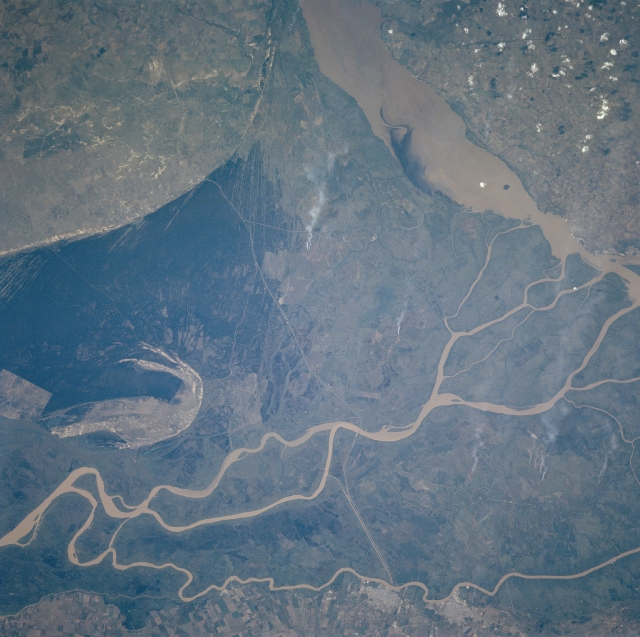 |
| NM23-721-526 Rio Parana Delta, Argentina Winter/Spring 1997 The Rio Parana has created a very broad delta and floodplain at the mouth of the river along the western end of the Rio de la Plata. This delta and floodplain extends from the noticeably curving line near the top of the image to almost touching the bottom edge of the picture. Several distributary channels of the river are shown as light colored, narrow, linear features that wind in a generally eastward direction. The floodplain has been extensively modified. The floodplain is visible due to the differing vegetation patterns and the sharp edges within the delta. The very thin, light-colored line that extends north-south across the delta (middle of the picture) appears to be a highway. Several individual smoke plumes can be seen on the flat but slightly elevated land east of the highway on the delta. Two cities, Zarate and Campana (brighter features lower middle) can be identified along the southern channel (and southern boundary of the Rio Parana). The broader, muddy Rio Uruguay is visible in the upper right quadrant of the picture. The Uruguay River marks the border between Argentina and Uruguay. |
| Images: | All Available Images Low-Resolution 321k |
|
| Mission: | NM23 |
|
| Roll - Frame: | 721 - 526 |
|
| Geographical Name: | ARGENTINA |
|
| Features: | RIO PARANA, BURN SCARS |
|
| Center Lat x Lon: | 33.5S x 59W |
|
| Film Exposure: | N | N=Normal exposure, U=Under exposed, O=Over exposed, F=out of Focus |
| Percentage of Cloud Cover-CLDP: | 5 |
|
| Camera:: | HB |
|
| Camera Tilt: | LO | LO=Low Oblique, HO=High Oblique, NV=Near Vertical |
| Camera Focal Length: | 100 |
|
| Nadir to Photo Center Direction: | SW | The direction from the nadir to the center point, N=North, S=South, E=East, W=West |
| Stereo?: | Y | Y=Yes there is an adjacent picture of the same area, N=No there isn't |
| Orbit Number: | |
|
| Date: | 19970403 | YYYYMMDD |
| Time: | GMT HHMMSS |
|
| Nadir Lat: | N |
Latitude of suborbital point of spacecraft |
| Nadir Lon: | E |
Longitude of suborbital point of spacecraft |
| Sun Azimuth: | Clockwise angle in degrees from north to the sun measured at the nadir point |
|
| Space Craft Altitude: | nautical miles |
|
| Sun Elevation: | Angle in degrees between the horizon and the sun, measured at the nadir point |
|
| Land Views: | PLAIN |
|
| Water Views: | DELTA, RIVER, SEDIMENT |
|
| Atmosphere Views: | |
|
| Man Made Views: | |
|
| City Views: | |
|
Photo is not associated with any sequences | ||
| NASA Home Page |
JSC Home Page |
JSC Digital Image Collection |
Earth Science & Remote Sensing |
|
This service is provided by the International Space Station program and the JSC Earth Science & Remote Sensing Unit, ARES Division, Exploration Integration Science Directorate.

|