
Geographic Region: ARGENTINA
Feature: LAKE VENADO
|
Geographic Region: ARGENTINA Feature: LAKE VENADO |
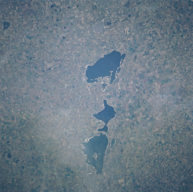 |
| NM23-721-519 Rio Cuarto Craters, Argentina Winter/Spring 1997 The northeast-southwest aligned string of lakes spanning about 19 miles (30 kilometers) is the result of about 10 oblong meteorite craters ranging in size from a few kilometers to about 820 feet (250 meters) along their long axis. The shape and alignment of the lakes suggests a low angle impact. Small meteorites were found in a crater confirming the lakes impact origin. The crater lakes have been dated at less than 10000 years old. From southwest to northeast, these lakes include Laguna de la Sal, Laguna Venado, Laguna Monte (lake with a large island near the center), Laguna Cochico, and Laguna Alsina. These lakes are located in west central Buenos Aires state. The landscape surrounding the lakes is covered by cultivated field patterns. |
| Images: | All Available Images Low-Resolution 336k |
|
| Mission: | NM23 |
|
| Roll - Frame: | 721 - 519 |
|
| Geographical Name: | ARGENTINA |
|
| Features: | LAKE VENADO |
|
| Center Lat x Lon: | 37S x 62.5W |
|
| Film Exposure: | N | N=Normal exposure, U=Under exposed, O=Over exposed, F=out of Focus |
| Percentage of Cloud Cover-CLDP: | 0 |
|
| Camera:: | HB |
|
| Camera Tilt: | LO | LO=Low Oblique, HO=High Oblique, NV=Near Vertical |
| Camera Focal Length: | 100 |
|
| Nadir to Photo Center Direction: | SW | The direction from the nadir to the center point, N=North, S=South, E=East, W=West |
| Stereo?: | Y | Y=Yes there is an adjacent picture of the same area, N=No there isn't |
| Orbit Number: | |
|
| Date: | 19970403 | YYYYMMDD |
| Time: | GMT HHMMSS |
|
| Nadir Lat: | N |
Latitude of suborbital point of spacecraft |
| Nadir Lon: | E |
Longitude of suborbital point of spacecraft |
| Sun Azimuth: | Clockwise angle in degrees from north to the sun measured at the nadir point |
|
| Space Craft Altitude: | nautical miles |
|
| Sun Elevation: | Angle in degrees between the horizon and the sun, measured at the nadir point |
|
| Land Views: | PLAIN |
|
| Water Views: | LAKE |
|
| Atmosphere Views: | |
|
| Man Made Views: | AGRICULTURE |
|
| City Views: | |
|
Photo is not associated with any sequences | ||
| NASA Home Page |
JSC Home Page |
JSC Digital Image Collection |
Earth Science & Remote Sensing |
|
This service is provided by the International Space Station program and the JSC Earth Science & Remote Sensing Unit, ARES Division, Exploration Integration Science Directorate.

|