
Geographic Region: ARGENTINA
Feature: RIO PARANA, AGRICULTURE
|
Geographic Region: ARGENTINA Feature: RIO PARANA, AGRICULTURE |
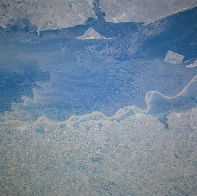 |
| NM23-719-448 Rio Parana, Argentina Winter/Spring 1997 The Rio Parana forms a broad, swampy floodplain (dark swath) in northeastern Argentina, which extends from Corrientes (north, near the Paraguayan border) to the western end of the Rio de la Plata estuary. This section of the floodplain is midway between Rosario and Buenos Aires. The main channel of the river (winding, light-colored band at center of image) flows southeastward along a bluff or escarpment, known as the Barranca (100 to 150 feet/ 30 to 45 meters high). Within the floodplain is a secondary channel, as well as old meander scars and shifting sandbars that are typical of a braided river. Extensive agricultural fields (rectilinear pattern) are observed southwest of the Rio Parana. This is part of the Pampas region of Argentina, noted for sheep and cattle ranching, as well as for cultivation of corn (maize), wheat, and alfalfa. (Refer to NM23-719-442, NM23-719-444, and NM23-719-446 for other images of the Rio Parana in northeast Argentina). |
| Images: | All Available Images Low-Resolution 428k |
|
| Mission: | NM23 |
|
| Roll - Frame: | 719 - 448 |
|
| Geographical Name: | ARGENTINA |
|
| Features: | RIO PARANA, AGRICULTURE |
|
| Center Lat x Lon: | 33.5S x 59.5W |
|
| Film Exposure: | N | N=Normal exposure, U=Under exposed, O=Over exposed, F=out of Focus |
| Percentage of Cloud Cover-CLDP: | 0 |
|
| Camera:: | HB |
|
| Camera Tilt: | LO | LO=Low Oblique, HO=High Oblique, NV=Near Vertical |
| Camera Focal Length: | 100 |
|
| Nadir to Photo Center Direction: | SE | The direction from the nadir to the center point, N=North, S=South, E=East, W=West |
| Stereo?: | Y | Y=Yes there is an adjacent picture of the same area, N=No there isn't |
| Orbit Number: | |
|
| Date: | 19970328 | YYYYMMDD |
| Time: | GMT HHMMSS |
|
| Nadir Lat: | N |
Latitude of suborbital point of spacecraft |
| Nadir Lon: | E |
Longitude of suborbital point of spacecraft |
| Sun Azimuth: | Clockwise angle in degrees from north to the sun measured at the nadir point |
|
| Space Craft Altitude: | nautical miles |
|
| Sun Elevation: | Angle in degrees between the horizon and the sun, measured at the nadir point |
|
| Land Views: | FLOOD PLAIN |
|
| Water Views: | RIVER, SWAMP |
|
| Atmosphere Views: | |
|
| Man Made Views: | AGRICULTURE |
|
| City Views: | |
|
Photo is not associated with any sequences | ||
| NASA Home Page |
JSC Home Page |
JSC Digital Image Collection |
Earth Science & Remote Sensing |
|
This service is provided by the International Space Station program and the JSC Earth Science & Remote Sensing Unit, ARES Division, Exploration Integration Science Directorate.

|