
Geographic Region: ARGENTINA
Feature: RIO PARANA, AGRICULTURE
|
Geographic Region: ARGENTINA Feature: RIO PARANA, AGRICULTURE |
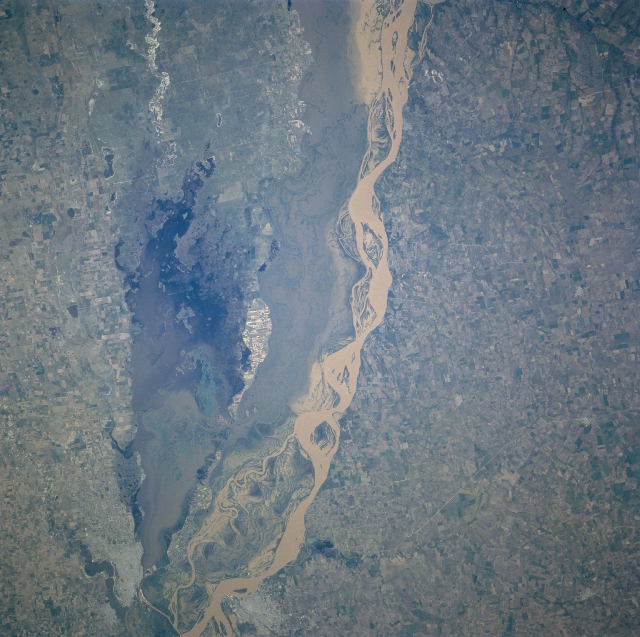 |
| NM23-719-446 Rio Parana, Argentina Winter/Spring 1997 The floodplain of the Rio Parana in northeast Argentina narrows in this section of the river. The two cities of Parana (along the east bank of the river) and Santa Fe (along the west bank) are visible along the southern edge of the image. The main channel (highly reflective surface) of the Rio Parana hugs the eastern edge of the floodplain of the river. A wider swath of muddy water occupies the more westerly part of the Rio Parana floodplain. Notice that a ponding of water has formed north of Santa Fe and that a channel connects the Rio Parana with the standing water, thereby providing a source of muddy water. A section of highway (narrow, light colored line) is visible northeast of Parana. The landscape on both sides of the Rio Parana is used extensively for agriculture. This particular scene in northeast Argentina begins the northern extent of region known as the Pampa, an area of fertile soils and grasslands that is highly productive in terms of agricultural output. (Refer to NM23-719-442, NM23-719-444, and NM23-719-448 for other images and information about this section of the Rio Parana in northeast Argentina). |
| Images: | All Available Images Low-Resolution 462k |
|
| Mission: | NM23 |
|
| Roll - Frame: | 719 - 446 |
|
| Geographical Name: | ARGENTINA |
|
| Features: | RIO PARANA, AGRICULTURE |
|
| Center Lat x Lon: | 31.5S x 60W |
|
| Film Exposure: | N | N=Normal exposure, U=Under exposed, O=Over exposed, F=out of Focus |
| Percentage of Cloud Cover-CLDP: | 0 |
|
| Camera:: | HB |
|
| Camera Tilt: | LO | LO=Low Oblique, HO=High Oblique, NV=Near Vertical |
| Camera Focal Length: | 100 |
|
| Nadir to Photo Center Direction: | SE | The direction from the nadir to the center point, N=North, S=South, E=East, W=West |
| Stereo?: | Y | Y=Yes there is an adjacent picture of the same area, N=No there isn't |
| Orbit Number: | |
|
| Date: | 19970328 | YYYYMMDD |
| Time: | GMT HHMMSS |
|
| Nadir Lat: | N |
Latitude of suborbital point of spacecraft |
| Nadir Lon: | E |
Longitude of suborbital point of spacecraft |
| Sun Azimuth: | Clockwise angle in degrees from north to the sun measured at the nadir point |
|
| Space Craft Altitude: | nautical miles |
|
| Sun Elevation: | Angle in degrees between the horizon and the sun, measured at the nadir point |
|
| Land Views: | FLOOD PLAIN |
|
| Water Views: | RIVER, SEDIMENT, LAKE |
|
| Atmosphere Views: | |
|
| Man Made Views: | AGRICULTURE |
|
| City Views: | |
|
Photo is not associated with any sequences | ||
| NASA Home Page |
JSC Home Page |
JSC Digital Image Collection |
Earth Science & Remote Sensing |
|
This service is provided by the International Space Station program and the JSC Earth Science & Remote Sensing Unit, ARES Division, Exploration Integration Science Directorate.

|