
Geographic Region: ARGENTINA
Feature: RIO PARANA, AGRICULTURE
|
Geographic Region: ARGENTINA Feature: RIO PARANA, AGRICULTURE |
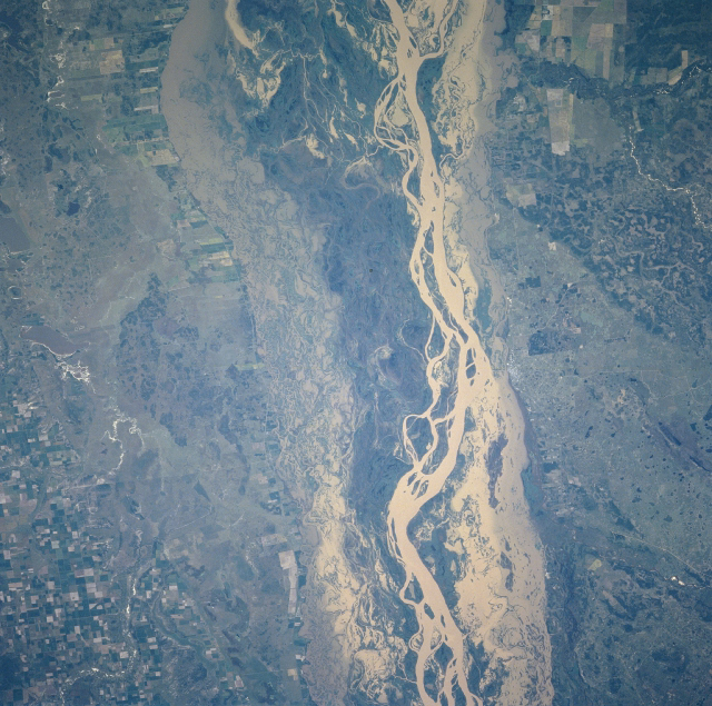 |
| Rio Parana, Argentina Winter/Spring 1997 The Rio Parana is one of the three major rivers in South America (the Amazon and Orinoco Rivers are the other two). Through northeast Argentina the river has a broad floodplain that averages approximately 20 miles (32 kilometers) in width and stretches from Corrientes northward to the large delta at the western end of the Rio de la Plata. As seen in this picture, the Rio Parana exhibits a winding and shifting course (highly reflective tan surface) that annually floods the extensive floodplain. The river's shallow channels frequently clog with sand bars, thereby rendering the river unreliable for transportation. Numerous tributary streams flow into the Rio Parana, mainly along the eastern side of the river. Angular patterns east and west of the floodplain indicate that some of the land along the river is used for agriculture. Darker areas (towards the center of the floodplain) on slightly higher terrain show where vegetation is growing. (Refer to NM23-719-444, NM23-719-446, and NM23-719-448 for other images of the Rio Parana in northeast Argentina.) |
| Images: | All Available Images Low-Resolution 475k |
|
| Mission: | NM23 |
|
| Roll - Frame: | 719 - 442 |
|
| Geographical Name: | ARGENTINA |
|
| Features: | RIO PARANA, AGRICULTURE |
|
| Center Lat x Lon: | 30S x 59.5W |
|
| Film Exposure: | N | N=Normal exposure, U=Under exposed, O=Over exposed, F=out of Focus |
| Percentage of Cloud Cover-CLDP: | 0 |
|
| Camera:: | HB |
|
| Camera Tilt: | LO | LO=Low Oblique, HO=High Oblique, NV=Near Vertical |
| Camera Focal Length: | 100 |
|
| Nadir to Photo Center Direction: | SE | The direction from the nadir to the center point, N=North, S=South, E=East, W=West |
| Stereo?: | Y | Y=Yes there is an adjacent picture of the same area, N=No there isn't |
| Orbit Number: | |
|
| Date: | 19970328 | YYYYMMDD |
| Time: | GMT HHMMSS |
|
| Nadir Lat: | N |
Latitude of suborbital point of spacecraft |
| Nadir Lon: | E |
Longitude of suborbital point of spacecraft |
| Sun Azimuth: | Clockwise angle in degrees from north to the sun measured at the nadir point |
|
| Space Craft Altitude: | nautical miles |
|
| Sun Elevation: | Angle in degrees between the horizon and the sun, measured at the nadir point |
|
| Land Views: | FLOOD PLAIN |
|
| Water Views: | RIVER, SEDIMENT |
|
| Atmosphere Views: | |
|
| Man Made Views: | AGRICULTURE |
|
| City Views: | |
|
Photo is not associated with any sequences | ||
| NASA Home Page |
JSC Home Page |
JSC Digital Image Collection |
Earth Science & Remote Sensing |
|
This service is provided by the International Space Station program and the JSC Earth Science & Remote Sensing Unit, ARES Division, Exploration Integration Science Directorate.

|