
Geographic Region: ARGENTINA
Feature: ACONQUIJA MOUNTAINS
|
Geographic Region: ARGENTINA Feature: ACONQUIJA MOUNTAINS |
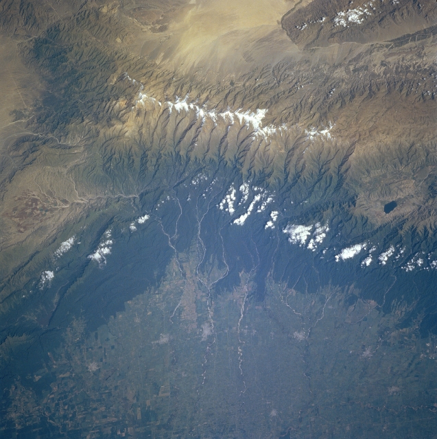 |
| NM23-719-436 Aconquija and Cajon Ranges, Argentina Winter/Spring 1997 The forested Aconquija Range, part of the Andes chain, includes many peaks exceeding 16,000 feet (4880 meters). The high plains to the east (bottom of image) are semi-arid agricultural lands producing mostly grains, cotton, and flax. Several small cities are discernible along the foothills of the Aconquija; from north to south (right to left) they are Monteros, Concepcion, Aguilares, and Villa Alberdi. Numerous streams, tributaries of the Dulce River, descend from the mountains into the plains past the cities. The southern Cajon Range is at upper right, and the yellowish Arenal flats are at upper center. |
| Images: | All Available Images Low-Resolution 340k |
|
| Mission: | NM23 |
|
| Roll - Frame: | 719 - 436 |
|
| Geographical Name: | ARGENTINA |
|
| Features: | ACONQUIJA MOUNTAINS |
|
| Center Lat x Lon: | 27.5S x 65.5W |
|
| Film Exposure: | N | N=Normal exposure, U=Under exposed, O=Over exposed, F=out of Focus |
| Percentage of Cloud Cover-CLDP: | 5 |
|
| Camera:: | HB |
|
| Camera Tilt: | LO | LO=Low Oblique, HO=High Oblique, NV=Near Vertical |
| Camera Focal Length: | 100 |
|
| Nadir to Photo Center Direction: | SE | The direction from the nadir to the center point, N=North, S=South, E=East, W=West |
| Stereo?: | N | Y=Yes there is an adjacent picture of the same area, N=No there isn't |
| Orbit Number: | |
|
| Date: | 19970328 | YYYYMMDD |
| Time: | GMT HHMMSS |
|
| Nadir Lat: | N |
Latitude of suborbital point of spacecraft |
| Nadir Lon: | E |
Longitude of suborbital point of spacecraft |
| Sun Azimuth: | Clockwise angle in degrees from north to the sun measured at the nadir point |
|
| Space Craft Altitude: | nautical miles |
|
| Sun Elevation: | Angle in degrees between the horizon and the sun, measured at the nadir point |
|
| Land Views: | MOUNTAIN, UPLAND, PLAIN |
|
| Water Views: | |
|
| Atmosphere Views: | |
|
| Man Made Views: | AGRICULTURE |
|
| City Views: | |
|
Photo is not associated with any sequences | ||
| NASA Home Page |
JSC Home Page |
JSC Digital Image Collection |
Earth Science & Remote Sensing |
|
This service is provided by the International Space Station program and the JSC Earth Science & Remote Sensing Unit, ARES Division, Exploration Integration Science Directorate.

|