Geographic Region: ARGENTINA
Feature: ANDES MOUNTAINS,GLACIERS
|
Geographic Region: ARGENTINA Feature: ANDES MOUNTAINS,GLACIERS |
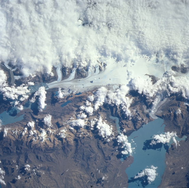 |
| NM23-718-501 Lake Viedma, Darwin Range Glaciers, Argentina Winter/Spring 1997 Although clouds cover most of the upper image (west), a small part of the Darwin Range ice field can be seen near the center; meltwater from the glacier enters the grayish-blue waters of Lake Viedma (lower right). The lake color is a result of the water containing rock flour - finely ground rock particles that are carried into glacial lakes by meltwater and remain in suspension. The ice fields of the southern Andes are remnants of a much larger glacier that covered the area 15,000 years ago. Melting of that large glacier started 13,000 years ago. During a glacial advance erosion caused by entrained boulder under the ice as well as the weight of the glacier creates basins. As glaciers in Argentina retreated, these large basin or troughs filled with meltwater to form the lakes that currently dot the area. The smaller present-day glaciers or ice fields are fed by the cool, moist westerly winds off the Pacific Ocean. The melting glaciers feed the lakes with fresh water. The outlet of Lake Viedma flows into Lake Argentino to the south. Lake Argentino is the source for Santa Cruz River, which flows eastward across Patagonia and into the Atlantic Ocean. |
| Images: | All Available Images Low-Resolution 346k |
|
| Mission: | NM23 |
|
| Roll - Frame: | 718 - 501 |
|
| Geographical Name: | ARGENTINA |
|
| Features: | ANDES MOUNTAINS,GLACIERS |
|
| Center Lat x Lon: | 50S x 73W |
|
| Film Exposure: | N | N=Normal exposure, U=Under exposed, O=Over exposed, F=out of Focus |
| Percentage of Cloud Cover-CLDP: | 70 |
|
| Camera:: | HB |
|
| Camera Tilt: | LO | LO=Low Oblique, HO=High Oblique, NV=Near Vertical |
| Camera Focal Length: | 250 |
|
| Nadir to Photo Center Direction: | SE | The direction from the nadir to the center point, N=North, S=South, E=East, W=West |
| Stereo?: | Y | Y=Yes there is an adjacent picture of the same area, N=No there isn't |
| Orbit Number: | |
|
| Date: | 19970325 | YYYYMMDD |
| Time: | GMT HHMMSS |
|
| Nadir Lat: | N |
Latitude of suborbital point of spacecraft |
| Nadir Lon: | E |
Longitude of suborbital point of spacecraft |
| Sun Azimuth: | Clockwise angle in degrees from north to the sun measured at the nadir point |
|
| Space Craft Altitude: | nautical miles |
|
| Sun Elevation: | Angle in degrees between the horizon and the sun, measured at the nadir point |
|
| Land Views: | MOUNTAIN, GLACIER |
|
| Water Views: | LAKE |
|
| Atmosphere Views: | |
|
| Man Made Views: | |
|
| City Views: | |
|
Photo is not associated with any sequences | ||
| NASA Home Page |
JSC Home Page |
JSC Digital Image Collection |
Earth Science & Remote Sensing |
|
This service is provided by the International Space Station program and the JSC Earth Science & Remote Sensing Unit, ARES Division, Exploration Integration Science Directorate.

|