
Geographic Region: FEDERAL REPUBLIC OF YUGOSLAVIA
Feature: LAKE SCUTARI, ADRIATIC COAST
|
Geographic Region: FEDERAL REPUBLIC OF YUGOSLAVIA Feature: LAKE SCUTARI, ADRIATIC COAST |
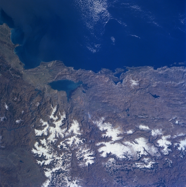 |
| NM23-707-423 Lake Scutari, Dinaric Alps, Yugoslavia/Albania Winter/Spring 1997 Lake Scutari and the rugged terrain of southwestern Yugoslavia and northwestern Albania can be seen in this southwest-looking view. Situated on the border between Montenegro Province, Yugoslavia (right) and Albania (left), Lake Scutari is 25 miles (40 km) long and from 4 to 8 miles (6 to 13 km) wide. The lake's depth and area varies seasonally. Floods sometimes occur in the area surrounding Lake Scutari in the winter. Once an inlet of the Adriatic Sea, Lake Scutari is now separated from the sea by an alluvial isthmus. Lake Scutari is fed by the Morala River at its north end and is drained by the Buene River southeastward in Albania to the Drin River. The rugged Dinaric Alps dominate the coastline northwest of Lake Scutari. The Dinaric Alps are chiefly cracked limestone strata that form long valleys and contain topographical oddities such as caves and disappearing rivers. The Gulf of Tivatski is visible just to the right of the center of the image. |
| Images: | Images: | NO IMAGES YET | |||
| Mission: | NM23 |
||||
| Roll - Frame: | 707 - 423 |
||||
| Geographical Name: | FEDERAL REPUBLIC OF YUGOSLAVIA |
||||
| Features: | LAKE SCUTARI, ADRIATIC COAST |
||||
| Center Lat x Lon: | 42.5N x 19.0E |
||||
| Film Exposure: | N | N=Normal exposure, U=Under exposed, O=Over exposed, F=out of Focus |
|||
| Percentage of Cloud Cover-CLDP: | 5 |
||||
| Camera:: | HB |
||||
| Camera Tilt: | LO=Low Oblique, HO=High Oblique, NV=Near Vertical |
||||
| Camera Focal Length: | 100 |
||||
| Nadir to Photo Center Direction: | The direction from the nadir to the center point, N=North, S=South, E=East, W=West |
||||
| Stereo?: | N | Y=Yes there is an adjacent picture of the same area, N=No there isn't |
|||
| Orbit Number: | |
||||
| Date: | 19970312 | YYYYMMDD |
|||
| Time: | GMT HHMMSS |
||||
| Nadir Lat: | N |
Latitude of suborbital point of spacecraft | |||
| Nadir Lon: | E |
Longitude of suborbital point of spacecraft | |||
| Sun Azimuth: | Clockwise angle in degrees from north to the sun measured at the nadir point |
||||
| Space Craft Altitude: | nautical miles |
||||
| Sun Elevation: | Angle in degrees between the horizon and the sun, measured at the nadir point |
||||
| Land Views: | COAST, MOUNTAIN, PLATEAU, FAULT |
||||
| Water Views: | LAKE |
||||
| Atmosphere Views: | |
||||
| Man Made Views: | |
||||
| City Views: | |
||||
Photo is not associated with any sequences | |||||
| NASA Home Page |
JSC Home Page |
JSC Digital Image Collection |
Earth Science & Remote Sensing |
|
This service is provided by the International Space Station program and the JSC Earth Science & Remote Sensing Unit, ARES Division, Exploration Integration Science Directorate.

|