
Geographic Region: ITALY
Feature: APPENNINES
|
Geographic Region: ITALY Feature: APPENNINES |
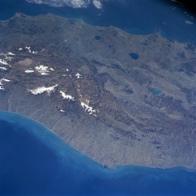 |
| NM23-707-417 Appennine Mountains, Italy Winter/Spring 1997 A large region of central Italy is visible in this synoptic, southeast view that extends from the Adriatic Sea coast (bottom) to the Tyrrhenian Sea coast (top). Three major physiographic provinces are observed in this image: the drier, less inhabited, rocky limestone tablelands and narrow plains of the east coast (bottom); the central part of the Alpine Mountain system, known as the Appennine Mountains, that extend northwest-southeast along the spine of peninsular Italy; and the area west of the Appennines that is made up of hills and volcanic features. The dark, oval-shaped features (Lake Bolsena-largest and Lake Bracciano) are water-filled calderas. Lake Trasimeno (aqua colored feature) is also visible near the right (middle) margin of the scene. On the east side of this central part of the Italian Peninsula, the rivers are close together and flow swiftly in short parallel courses into the Adriatic Sea. The concentration of whitish features reveals the location of snow covered higher elevations of the Appennine Mountains, many exceeding 8000 feet (2440 meters) above sea level. Rome, the Eternal City, is located south of Lake Bracciano (near top center of the image) in the Tiber River Valley. Numerous passes and tunnels through the mountains facilitate ground traffic between the east-west coasts. |
| Images: | All Available Images Low-Resolution 321k |
|
| Mission: | NM23 |
|
| Roll - Frame: | 707 - 417 |
|
| Geographical Name: | ITALY |
|
| Features: | APPENNINES |
|
| Center Lat x Lon: | 42.5N x 13.0E |
|
| Film Exposure: | N | N=Normal exposure, U=Under exposed, O=Over exposed, F=out of Focus |
| Percentage of Cloud Cover-CLDP: | 5 |
|
| Camera:: | HB |
|
| Camera Tilt: | LO | LO=Low Oblique, HO=High Oblique, NV=Near Vertical |
| Camera Focal Length: | 100 |
|
| Nadir to Photo Center Direction: | E | The direction from the nadir to the center point, N=North, S=South, E=East, W=West |
| Stereo?: | Y | Y=Yes there is an adjacent picture of the same area, N=No there isn't |
| Orbit Number: | |
|
| Date: | 19970312 | YYYYMMDD |
| Time: | GMT HHMMSS |
|
| Nadir Lat: | N |
Latitude of suborbital point of spacecraft |
| Nadir Lon: | E |
Longitude of suborbital point of spacecraft |
| Sun Azimuth: | Clockwise angle in degrees from north to the sun measured at the nadir point |
|
| Space Craft Altitude: | nautical miles |
|
| Sun Elevation: | Angle in degrees between the horizon and the sun, measured at the nadir point |
|
| Land Views: | MOUNTAIN |
|
| Water Views: | SEA, LAKE |
|
| Atmosphere Views: | |
|
| Man Made Views: | |
|
| City Views: | |
|
Photo is not associated with any sequences | ||
| NASA Home Page |
JSC Home Page |
JSC Digital Image Collection |
Earth Science & Remote Sensing |
|
This service is provided by the International Space Station program and the JSC Earth Science & Remote Sensing Unit, ARES Division, Exploration Integration Science Directorate.

|